


Jordan Thompson examines... The geology of Whitrope Tunnel
Jordan Thompson examines… The geology of Whitrope Tunnel
Tunnels are remarkable feats of engineering and continue to present a combination of challenges – careful and precise design, and the inherent risks to those involved in their construction. But those risks were of a far greater magnitude in the Victorian era with large numbers of navvies either seriously injured or losing their lives.
Disused tunnels of this era offer an insight into the methods of construction and how health and safety standards today would have shut the site down on day one. Not all, but a large number of these forgotten relics expose the geology that had to be both overcome and worked with to construct them.
Closed in 1969, Whitrope Tunnel, part of the Waverley line in the Scottish Borders, offers a fascinating glimpse into over 400 million years of Earth’s history recorded within the 1,208 yard (1,105 metres) bore, as well as ways in which the workers took advantage of the rock they were breaking though beneath Sandy Edge.
Whitrope covers four geological groups that are each defined as two or more formations that share similar lithological characteristics; formations being varying thicknesses of strata with a comparable lithology, facies and other similar properties.
The Riccarton Group
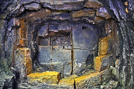
The oldest group dating from the Wenlock series (433.4-427.4 million years ago) of the Silurian Period (443.8-419.2 million years ago), is the Riccarton Group. They are steeply dipping turbidity current deposits consisting of greywackes (sandstones), mudstones with siltstones. A disturbance such as an earthquake caused the sediments to move as an underwater avalanche and be deposited as distinct beds of the coarser grained greywacke sandstones and finer sediments, the mudstones and siltstones.
An Ocean known as the Iapetus began to close during the early part of the Ordovician Period (485.4-443.8 million years ago) and led to the collision of the continents of Laurentia, Avalonia and Baltica (Caledonian Orogeny). By the mid Ordovician, the Iapetus Oceanic crust was being subducted beneath the Laurentian continental margin, bringing Laurentia and Avalonia closer together and ultimately the collision with one another. The Iapetus Ocean had closed by the mid-Wenlock of the Silurian Period and Laurentia had overridden Avalonia, bringing with it the southern uplands accretionary complex which were sediments scraped from the subducted Oceanic crust. The Riccarton Group was deposited within a foreland basin ahead of the continuously advancing complex and by the beginning of the Ludlow Epoch (422.9-418.7 million years ago) had become part of a foreland fold and thrust belt setting within the accretionary complex. This created the steep dipping strata seen in the tunnel with the first contact of the group 74 metres from north portal and last noted at 110 metres.
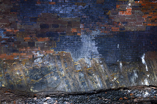
Photo: Jordan Thompson
These folded rocks were then uplifted and exposed to subaerial erosional processes leaving an irregular surface and later buried beneath sediment, creating an angular unconformity very similar to the world famous Hutton’s Unconformity north of Berwick-upon-Tweed at Siccar Point. Whitrope Tunnel provides an excellent example of this geological feature.
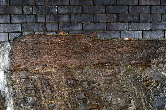
Photo: Jordan Thompson
The Stratheden Group
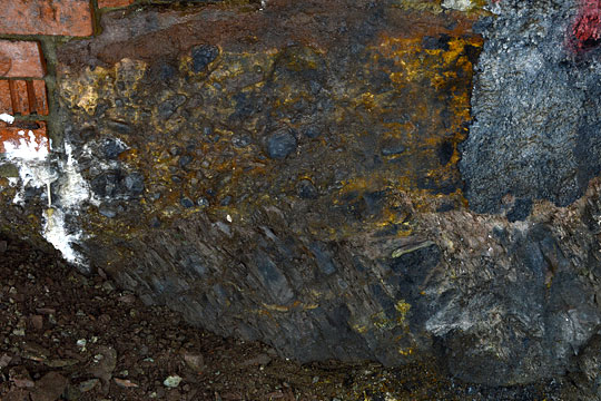
Photo: Jordan Thompson
A sequence of gently dipping rock formed between the Frasnian to Famennian stages (382.7-358.9 million years ago) of the Late Devonian period (419.2-358.9 million years ago) and often referred as the Upper old red sandstone due in part to their distinct red colour caused by haematite coated grains, make up the majority of the natural rock and the tunnel lining. These rocks were formed dominantly in fluvial semi-arid depositional environments as well as some Aeolian and lacustrine. The Southern uplands Terrane, a product of the Caledonian Orogeny, began to erode bringing about the accumulation of sediments into alluvial basins formed as a result of the Acadian orogeny of the early to mid-Devonian period. The Stratheden Group is evident within metres of the north portal and is present all the way towards No.4 shaft (789 metres). They consist of a majority of fine to coarse sandstones, conglomerates, mudrock (siltstone and mudstone), most of which are visible. Mudrock was apparent in some beds but proved more difficult to identify in part to the highly weathered state of the rock.
Many areas have been left exposed and engineered as a rock footing for the masonry/brick sidewalls and crown, attesting to the solidity of these rocks.
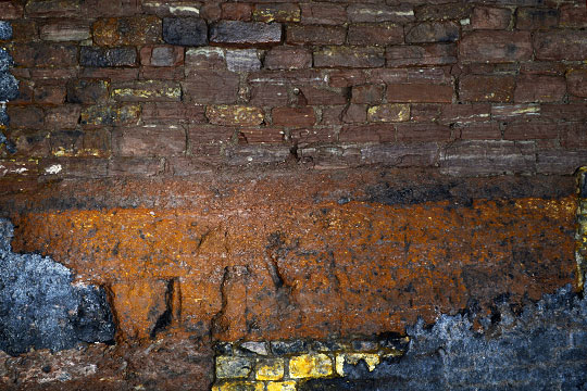
Photo: Jordan Thompson
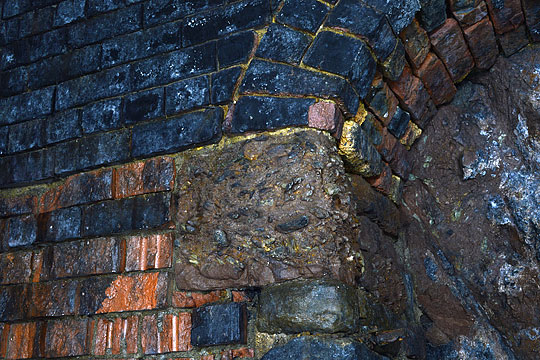
Photo: Jordan Thompson
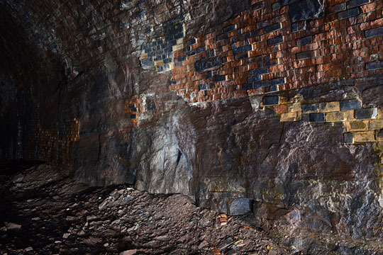
Photo: Jordan Thompson
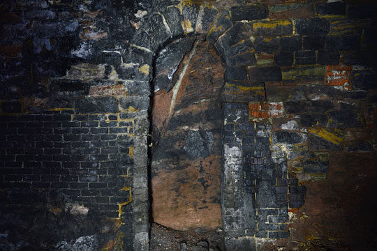
Photo: Jordan Thompson
Exposures of the Stratheden Group are numerous; in sidewalls (rock footings) and the back of refuges as they’re unlined. Overall, as you travel south, the conglomerates thin from around 250 metres and slowly transition to sandstones which contain minor beds of conglomerate. Red mudrocks are less common and their fine grained and highly weathered nature allows them to stand out against the coarser grained sandstones. These were first noted just south of the 325 metre point.
Overall the condition of tunnel where the Stratheden rock has been encountered remains generally stable with weathered beds of finer rock producing piles of material. Red brick and engineering brick are a common sight where patch repairs were required. It remains quite dry and falls of masonry are minor; the Stratheden rock remaining the dominant type for the lining.
No.1 shaft (approx. 98 metres from the north end) and No.2 shaft (288 metres) both show little in the way of water ingress, but enough to locate them. At 325 metres, an area where calcite (Calthemite) has deposited upon the sidewalls is very obvious and required a catchment tray (missing) and guttering. Beyond this point it remains mostly dry with only a small influx of water from No.3 shaft (531 metres). Once in close proximity to No.4 shaft (789 metres), water ingress becomes more of an issue.
There comes a point where the Stratheden Group transitions to the Younger Inverclyde Group. Why is there a marked change in geology?
The Whitrope Fault and Inverclyde Group
The Inverclyde Group belongs within the Tournasian stage (358.9-346.7 million years ago) of the Carboniferous Period (359.2-299 million years ago) and marks the deposition of sediments within the Northumberland-Solway trough which formed due to extensional tectonism beginning in the late Devonian Period. The uppermost part of the group, the Ballagan Formation, designates mudstones that are separated by beds of sandstone and thin interbeds of limestone which the tunnel was bored through. The environments consisted of fluvial, alluvial fan, lacustrine (lakes), lagoonal and some marine in a seasonally arid climate.
A marked change occurs between No.4 shaft and the south portal in both the features and condition of the tunnel. A geological fault mapped just south of this shaft separates the Stratheden from the Inverclyde Group of which the fluvial sandstones of the Whita sandstone beds (Ballagan Formation) are identified on BGS mapping. The precise location of the fault and the sudden transition to the Inverclyde Group was not apparent. Rock footings also become less significant, most certainly a result of the change in geology.
Just beyond the 700 metre mark and preceding the mapped fault, the red sandstones were observed with a distinct pale red/pink colouration. It can’t be ascertained in either case but may indicate the Whita Sandstone beds of the Ballagan formation or simply be a variance in the Stratheden Group. This sandstone was still evident in an exposure at 840 metres.
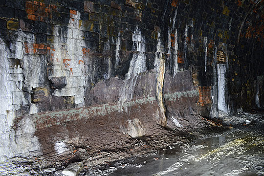
Photo: Jordan Thompson
Water ingress is an issue Whitrope Tunnel has obviously always endured, judging by the number of catchment trays and guttering, the majority of which are now corroded or missing entirely. Hidden shaft locations are inherently a major factor whereby surface water can more easily percolate and, in the case of No.4 shaft, create quite a deluge. Ingress is apparent as you travel from the north portal but remains quite dry up until this point.
Continuing south from No.4 shaft, further areas where ingress had been a major problem necessitated the introduction of a water management system to gain some control. Note should be made of the drainage system at Whitrope. Much of the installation is now in severe disrepair, specifically at shaft locations. However, the central drainage channel is still working and directing water out to the north. This is aided by the tunnel’s 1:96 falling gradient to the north, the south portal being located close to Whitrope Summit (1,006 feet/307 metres ASL).
Calcite (calthemite) deposits may well be in part the result of the fault down throwing younger and more permeable carbonate bearing rock of the Inverclyde Group (Ballagan Formation). Small burns flow across the area above, further worsening the problem. The result of this has brought about fascinating formations upon the sidewalls and ground including calcite-enveloped ballast and fallen guttering now permanently ‘welded’ to the floor. As already noted, fewer rock footings are identified towards the south portal, with refuges often providing the best glimpse of the geology, a number of which are now masked by calthemite deposits.
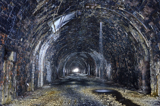
Photo: Jordan Thompson

Photo: Jordan Thompson
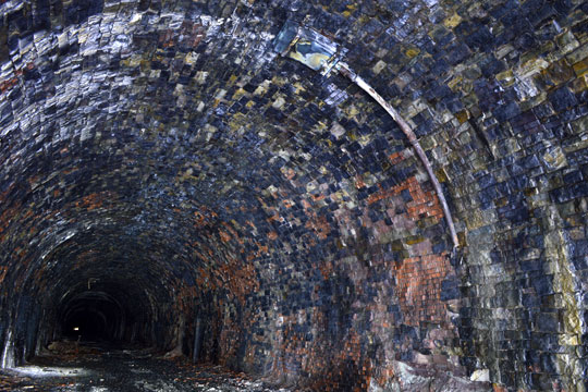
Photo: Jordan Thompson
Located at 928 metres, a refuge offers what may be the first evidence of the Inverclyde Group. The main distinction of tunnel exposures of the Stratheden Group is the red colouration of the sandstone/conglomerate dominated facies, intermittent mudrock and lack of carbonate beds. The refuge exposures from this point onwards present a majority of mudstone, shale, sandstone and carbonate beds. This is very likely to be the Ballagan Formation. The masonry is increasingly dominated by white/yellow sandstones, which support the geological change and what the workers were encountering and making use of. Useable rock between No.4 shaft and the south portal must have been limited compared to that further north. No.5 shaft (997 metres) lacks any deluge and retains its original marker upon the sidewall, whereas all other shafts either have no marker or they lie forgotten on the tunnel floor.
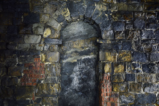
Photo: Jordan Thompson
The Border Group
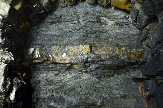
Photo: Jordan Thompson
BGS mapping designates the Border Group just within the south Portal. This group was deposited during the Visean stage (346.7-330.9 million years ago) of the carboniferous period and shares similarities to the Inverclyde Group’s Ballagan Formation. It is younger and the lower part of the group (Lyne Formation) comprises sequences of sandstone, siltstone, mudstone and limestone beds that formed in a variety of environments encompassing fluvial, deltaic, peritidal and marine. The distinction between the Inverclyde and lower Border Group – and where this occurs – is difficult hence the uncertainty in assigning them as distinct geological groups in the past. A collapse at the south portal, resulting in blockage of the tunnel and installation of substantial fencing, gives a rare glimpse above the crown and the dangerous state this section is in. Wave rippled bedding surfaces were evident in the fall material.
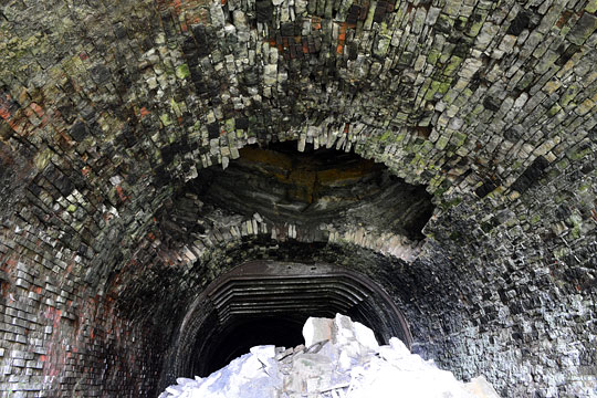
Photo: Jordan Thompson
Compared with the Riccarton and specifically the Stratheden Group – where rock is suitable as a footing material for the sidewalls and arch, a lack of water ingress and any of the minor collapses appearing to be more masonry than natural bedrock – both the Inverclyde and Border Group rock must have dealt a higher degree of danger to the workers constructing the tunnel. The retaining walls at the north portal are minor in comparison to those at the south portal; more evidence of the instability of the geology at the south end. It is very easy to overlook these factors and more so in the case of a tunnel with a full lining where the geology is hidden away for good.
Overall it was a great experience to locate and write about the condition of the tunnel and the changes in its geology after gaining a degree in Geology in 2013, but following other career paths since. Whether or not Whitrope Tunnel will see trains pass through it again is difficult to foresee. Due to its dangerous condition at the south end and the necessary surveying and repair of not only the collapse but the tunnel lining, it all factors down to cost and whether this section of line is seen as a viable option to be reopened. The decades of neglect have taken their toll and issues such as the collapse will only get worse, entailing greater cost and decreasing the chance of reuse.
However, its repair and reinstatement is most certainly a possibility and one I would be pleased to see in the near future. The dangerous and back-breaking work endured by the builders of Whitrope Tunnel in an isolated and unforgiving environment must certainly be another reason not to allow it to be infilled and forgotten like many of the magnificent disused tunnels in the UK.
Click here for a longitudinal section through the tunnel (PDF) (109kB)
More Information
| Forgotten Relics | Gallery of photos showing the tunnel |
| ‘Navvyman’ by Dick Sullivan | Chapter of a book describing the tunnel’s construction |
| Wikipedia | Brief overview of the tunnel |
| Historic Environment Scotland | Details of the tunnel’s listing |
