Pencader Tunnel
Pencader Tunnel
![The south-west portal has a leaking aqueduct carrying a water channel over its corner and masonry buttresses at either side.](http://www.forgottenrelics.org/wp-content/uploads/2023/03/image1-175.jpg)
![The lining comprises stone sidewalls and a brick arch at the entrances.](http://www.forgottenrelics.org/wp-content/uploads/2023/03/image2-175.jpg)
![Around 315 yards from the south portal is the first of Pencader's two ventilation shafts which opens up into a chamber above the lining.](http://www.forgottenrelics.org/wp-content/uploads/2023/03/image3-175.jpg)
![Beyond its extremeties, the bore is entirely brick-lined and mostly dry.](http://www.forgottenrelics.org/wp-content/uploads/2023/03/image4-174.jpg)
![About 710 yards in, the northern shaft - not the neatest you'll ever see - has been repaired and braced with ironwork.](http://www.forgottenrelics.org/wp-content/uploads/2023/03/image5-174.jpg)
![The shaft's surface structure - much shorter than the southern one - has been extensively repointed following abuse by abseilers.](http://www.forgottenrelics.org/wp-content/uploads/2023/03/image6-169.jpg)
![An archway cut in the sidewall - blocked by tipped spoil at the entrance - leads to a horizontal gallery.](http://www.forgottenrelics.org/wp-content/uploads/2023/03/image7-160.jpg)
![Rumour has it that the passageway was driven as an escape route in case of an accident but the more likely explanation is that it provided a means of removing spoil during construction.](http://www.forgottenrelics.org/wp-content/uploads/2023/03/image8-144.jpg)
![Now substantially blocked, the passage emerges close to a house.](http://www.forgottenrelics.org/wp-content/uploads/2023/03/image9-123.jpg)
![Some of the refuges reveal exposed rock at their rear, but the sidewalls also host a number of other arched openings - less that two feet in height - the purpose of which is not clear.](http://www.forgottenrelics.org/wp-content/uploads/2023/03/image10-97.jpg)
![The tunnel is 45 chains long so what does 65 indicate?](http://www.forgottenrelics.org/wp-content/uploads/2023/03/image11-79.jpg)
![The curved northern section gives way to Carmarthenshire daylight as mud makes its presence felt. Note the change in profile.](http://www.forgottenrelics.org/wp-content/uploads/2023/03/image12-56.jpg)
![The diminutive north-east entrance has a noticeably tighter gauge than the portal at the opposite end.](http://www.forgottenrelics.org/wp-content/uploads/2023/03/image13-42.jpg)
![](http://www.forgottenrelics.org/wp-content/uploads/2023/03/image1-175.jpg)
![](http://www.forgottenrelics.org/wp-content/uploads/2023/03/image2-175.jpg)
![](http://www.forgottenrelics.org/wp-content/uploads/2023/03/image3-175.jpg)
![](http://www.forgottenrelics.org/wp-content/uploads/2023/03/image4-174.jpg)
![](http://www.forgottenrelics.org/wp-content/uploads/2023/03/image5-174.jpg)
![](http://www.forgottenrelics.org/wp-content/uploads/2023/03/image6-169.jpg)
![](http://www.forgottenrelics.org/wp-content/uploads/2023/03/image7-160.jpg)
![](http://www.forgottenrelics.org/wp-content/uploads/2023/03/image8-144.jpg)
![](http://www.forgottenrelics.org/wp-content/uploads/2023/03/image9-123.jpg)
![](http://www.forgottenrelics.org/wp-content/uploads/2023/03/image10-97.jpg)
![](http://www.forgottenrelics.org/wp-content/uploads/2023/03/image11-79.jpg)
![](http://www.forgottenrelics.org/wp-content/uploads/2023/03/image12-56.jpg)
![](http://www.forgottenrelics.org/wp-content/uploads/2023/03/image13-42.jpg)
Bored through Ordovician shales, the single-track tunnel south-west of Pencader – also known locally as Alltwalis or Dolgran Tunnel – was built to Brunel’s broad gauge. It formed part of the Llanpumsaint-Pencader section of the Carmarthen & Cardigan Railway, taking the line between the valleys of Skanda Vale and Dolgran.
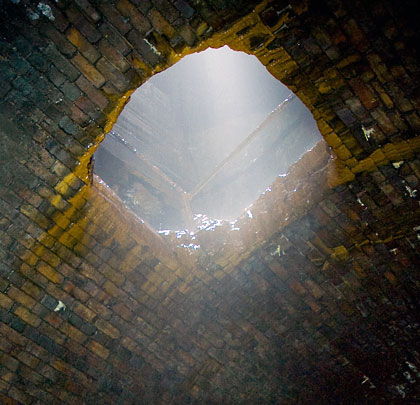
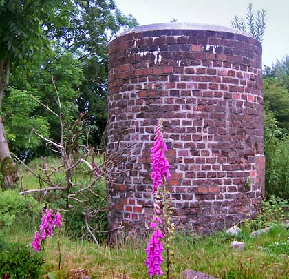
Brunel was one of several engineers to survey the line although his was not the design finally adopted, this being longer to provide easier gradients. At 988 yards in length, the tunnel is straight for most of its length before starting to curve south close to the more northerly of two construction shafts, later used for ventilation purposes. Close to this point is a side gallery – now ‘blind’ – which heads horizontally to the surface, emerging close to a house. This was reputedly built as an emergency escape route but more likely was used as means of removing spoil from the excavation.
The work was contracted to Jays of London and got underway in the spring of 1857, with the heading being driven from both ends and two shafts, creating six working faces. Many of the horses used to haul away the spoil died from disease and were buried in the field in which the northern shaft is located.
In 1859, to help reduce costs, the C&C applied for Parliamentary permission to convert the route from broad to standard gauge. This was declined. Activities were temporarily halted in May 1860 with 576 yards excavated; when they resumed, completion was expected around the New Year but this slipped to March 1861.
Construction of the railway either side of the tunnel continued for almost three years, with Holdens taking over the work from Jays. The southern approach involved numerous cuttings and embankments.
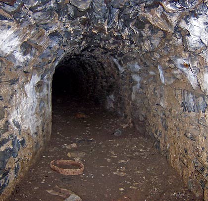
Track had been laid through the tunnel by December 1863 and the Board of Trade inspected it in January 1864, with the first train passing through on 1st April 1864. At this time it was still unlined – a watchman being appointed to monitor for rock falls.
The construction costs bankrupted the C&C which gave way to the Great Western in 1881. Conversion to standard gauge had occurred nine years earlier.
The withdrawal of passenger services came in 1965 but the line continued to carry freight until 28th September 1973.
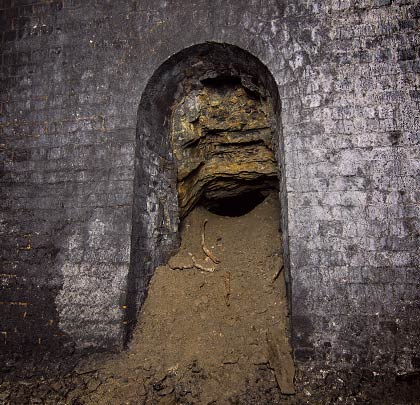
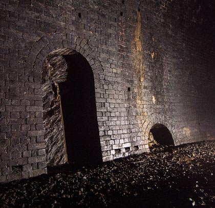
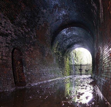
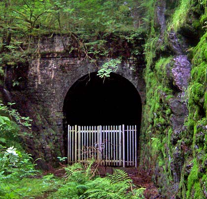
The tunnel is muddy at both ends but the majority of its interior remains dry thanks to the natural drainage resulting from its position at the line’s summit. A small aqueduct takes a water course across the western corner of the south portal. The brick lining is in very reasonable condition.