Litton Tunnel
Litton Tunnel
![The land rises sharply to the tunnel's south side, ensuring only a short northern approach cutting had to be excavated.](http://www.forgottenrelics.org/wp-content/uploads/2023/03/image1-237.jpg)
![The northernmost section of tunnel features near-vertical sidewalls and a segmental arch springing off high haunches, but the profile changes within a few yards.](http://www.forgottenrelics.org/wp-content/uploads/2023/03/image2-237.jpg)
![With their perished mortar joints, the sidewalls and springers are stone whilst the arch - together with patch repairs - are in brick.](http://www.forgottenrelics.org/wp-content/uploads/2023/03/image3-237.jpg)
![A small chamber extends a few feet back from the south wall, reputedly in connection with mining.](http://www.forgottenrelics.org/wp-content/uploads/2023/03/image4-234.jpg)
![Except for a short straight section at its east end, the tunnel curves to the south on a radius of 40 chains.](http://www.forgottenrelics.org/wp-content/uploads/2023/03/image5-231.jpg)
![Holes in the soot reveal the masonry's true colours.](http://www.forgottenrelics.org/wp-content/uploads/2023/03/image6-222.jpg)
![Formed in brick, refuges were inserted at 22-yard centres in 1914 in preparation for the introduction of new 9'3'' wide stock](http://www.forgottenrelics.org/wp-content/uploads/2023/03/image7-211.jpg)
![Looking westwards from close to the eastern entrance.](http://www.forgottenrelics.org/wp-content/uploads/2023/03/image8-186.jpg)
![Although structurally sound, some sections of the arches' brickwork are badly spalled. Any loose material has been removed.](http://www.forgottenrelics.org/wp-content/uploads/2023/03/image9-161.jpg)
![The modest east portal cowers at the end of an impressive and vertically-sided approach cutting.](http://www.forgottenrelics.org/wp-content/uploads/2023/03/image10-120.jpg)
![Lighting was installed in 2011 as part of works to accommodate the Monsal Trail cycle route through four previously-closed tunnels.](http://www.forgottenrelics.org/wp-content/uploads/2023/03/image11-100.jpg)
![A concrete-encased water main sits at the foot of the south wall.](http://www.forgottenrelics.org/wp-content/uploads/2023/03/image12-73.jpg)
![The pristine western approaches in operational times.](http://www.forgottenrelics.org/wp-content/uploads/2023/03/image13-56.jpg)
![1C82 enjoys the falling gradient as it bursts out of the tunnel's east end.](http://www.forgottenrelics.org/wp-content/uploads/2023/03/image14-44.jpg)
![](http://www.forgottenrelics.org/wp-content/uploads/2023/03/image1-237.jpg)
![](http://www.forgottenrelics.org/wp-content/uploads/2023/03/image2-237.jpg)
![](http://www.forgottenrelics.org/wp-content/uploads/2023/03/image3-237.jpg)
![](http://www.forgottenrelics.org/wp-content/uploads/2023/03/image4-234.jpg)
![](http://www.forgottenrelics.org/wp-content/uploads/2023/03/image5-231.jpg)
![](http://www.forgottenrelics.org/wp-content/uploads/2023/03/image6-222.jpg)
![](http://www.forgottenrelics.org/wp-content/uploads/2023/03/image7-211.jpg)
![](http://www.forgottenrelics.org/wp-content/uploads/2023/03/image8-186.jpg)
![](http://www.forgottenrelics.org/wp-content/uploads/2023/03/image9-161.jpg)
![](http://www.forgottenrelics.org/wp-content/uploads/2023/03/image10-120.jpg)
![](http://www.forgottenrelics.org/wp-content/uploads/2023/03/image11-100.jpg)
![](http://www.forgottenrelics.org/wp-content/uploads/2023/03/image12-73.jpg)
![](http://www.forgottenrelics.org/wp-content/uploads/2023/03/image13-56.jpg)
![](http://www.forgottenrelics.org/wp-content/uploads/2023/03/image14-44.jpg)
30th May 1863 saw the opening of an exceptional section of railway, eventually forming part of a main line link between London and Manchester. Built by the Midland, it cut a route through the limestone landscape of Derbyshire’s Wye Valley between Hassop and Buxton, demanding eight tunnels totalling 2,426 yards, two major viaducts and a number of smaller ones in the space of just 11 miles. But the audacity and investment did not live long. Barely a century after it opened, most of the route became an unlikely victim of the Beeching-era cuts, officially closing on 1st July 1968.
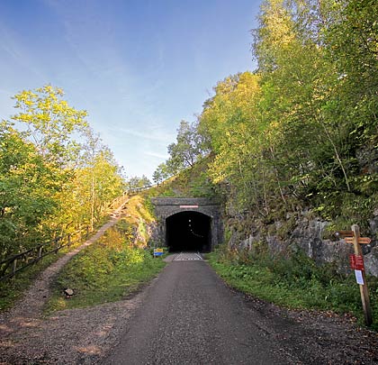
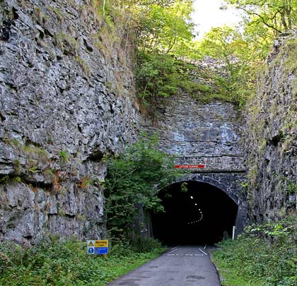
In 1981, the Peak District National Park Authority concluded lengthy negotiations with British Rail to secure the trackbed. Along it was laid the Monsal Trail – a nine-mile path linking Blackwell Mill Junction, east of Buxton, with a bridge over Coombs Road on the Matlock side of Bakewell. Since the summer of 2011, four of the tunnels – which had previously been closed for safety reasons – have been opened up for walkers, cyclists and horse riders to use, creating an easy linear connection between the Trail’s two ends.
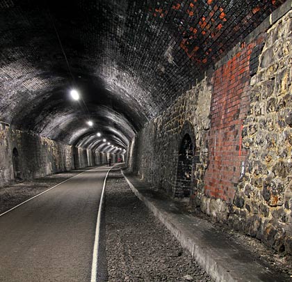
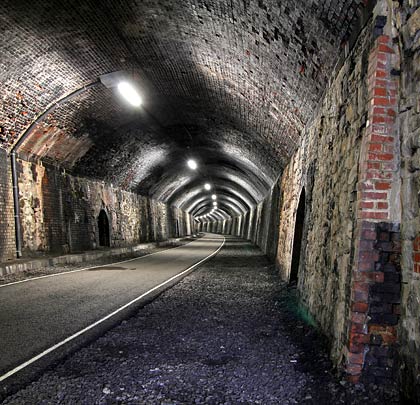
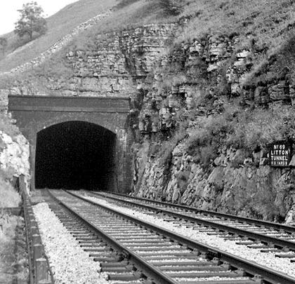
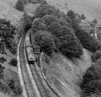
Litton Tunnel, structure number 69, follows a curved alignment, extending for 515 yards. Neither approach cutting is long thanks to the steeply rising hillside on its south side. At the east end, the cutting features impressive vertical rock faces.
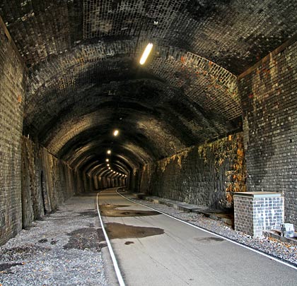
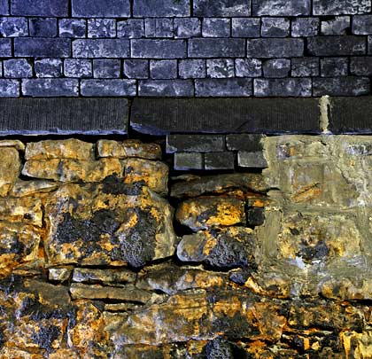
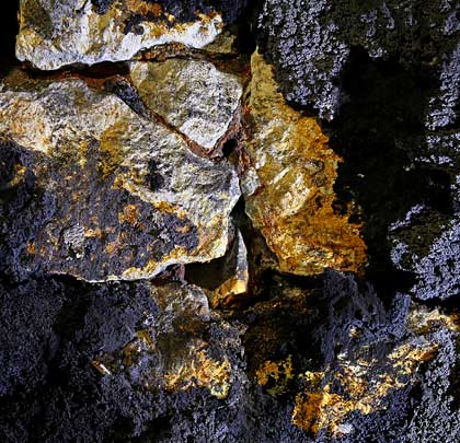
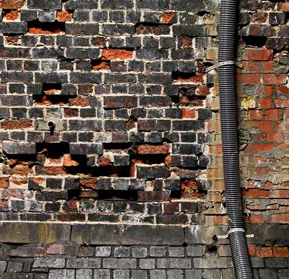
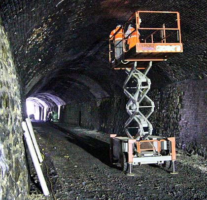
Westbound trains encountered a very short straight section before a long southerly curve of 40 chains radius. The gradient throughout rises at 1:100. The predominant lining material is engineering brick although patch repairs – some of them extensive – have been carried out in both red brick and masonry. The tunnel’s segmental roof arch is supported on limestone walls which lean outwards at the top. At the west end, a change in section sees much higher side walls and an arch with a very shallow rise.
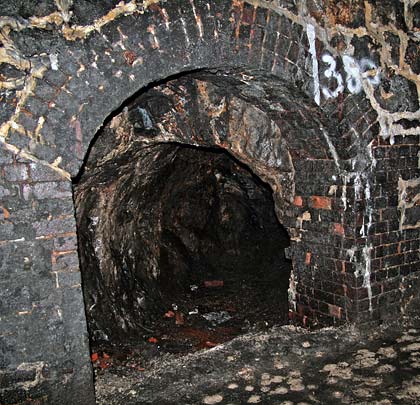
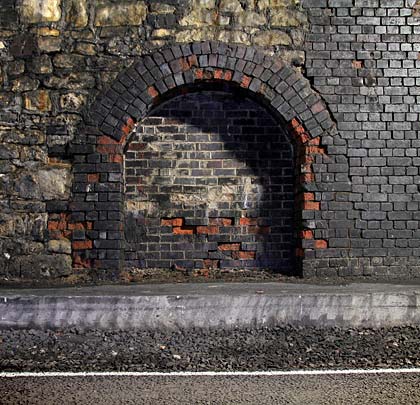
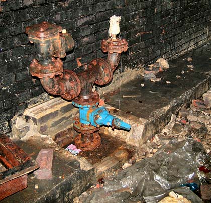
Refuges of inconsistent sizes are provided at both sides. The installation of a 12″ concrete-encased water main, located at the foot of the south wall, was authorised in 1979. One refuge in the south wall leads to a short chamber, reputedly cut in connection with mining activity. Whilst generally dry, small deposits of calcite are found in places.