Hook Norton Tunnel
Hook Norton Tunnel
![The north portal is brick-built with buttresses to both sides. The central section of parapet has been lost. At the foot of the eastern wing wall are the remains of a p-way cabin.](http://www.forgottenrelics.org/wp-content/uploads/2023/03/image1-144.jpg)
![Helping to reveal the tunnel's elliptical profile - and the possibility of an invert - is one of its refuges.](http://www.forgottenrelics.org/wp-content/uploads/2023/03/image2-144.jpg)
![Two abandoned sleepers languish in mud near the northern end.](http://www.forgottenrelics.org/wp-content/uploads/2023/03/image3-144.jpg)
![A row of iron fixings served an unknown purpose.](http://www.forgottenrelics.org/wp-content/uploads/2023/03/image4-143.jpg)
![Lined in brick, the tunnel incorporates an obvious cant and a curve to the west of approximately 52 chains in radius.](http://www.forgottenrelics.org/wp-content/uploads/2023/03/image5-143.jpg)
![Water ingress is considerable in places, resulting in a very wet section towards the middle of the tunnel and mud from there northwards.](http://www.forgottenrelics.org/wp-content/uploads/2023/03/image6-140.jpg)
![A hole is cut in the side wall, allowing a spring to drain into the tunnel.](http://www.forgottenrelics.org/wp-content/uploads/2023/03/image7-134.jpg)
![Deteriorating brickwork around one of the refuges.](http://www.forgottenrelics.org/wp-content/uploads/2023/03/image8-120.jpg)
![Spray concrete was applied to the lining as a protection measure close to the south portal, but it is now crumbling away.](http://www.forgottenrelics.org/wp-content/uploads/2023/03/image9-103.jpg)
![The blockwall - with high-level holes for bats - at the south end.](http://www.forgottenrelics.org/wp-content/uploads/2023/03/image10-83.jpg)
![The portal - revealing a lining that comprises six rings of brick - is gradually being enveloped by foliage.](http://www.forgottenrelics.org/wp-content/uploads/2023/03/image11-65.jpg)
![The northern portal captured in 1976, before the loss of its parapet.](http://www.forgottenrelics.org/wp-content/uploads/2023/03/image12-46.jpg)
![After closure, the south entrance remained open for the inquisitive.](http://www.forgottenrelics.org/wp-content/uploads/2023/03/image13-34.jpg)
![Looking south through the curved approach cutting, the sides of which have since collapsed in places.](http://www.forgottenrelics.org/wp-content/uploads/2023/03/image14-26.jpg)
![A mixed goods service leaves the north portal bound for Hook Norton.](http://www.forgottenrelics.org/wp-content/uploads/2023/03/image15-14.jpg)
![](http://www.forgottenrelics.org/wp-content/uploads/2023/03/image1-144.jpg)
![](http://www.forgottenrelics.org/wp-content/uploads/2023/03/image2-144.jpg)
![](http://www.forgottenrelics.org/wp-content/uploads/2023/03/image3-144.jpg)
![](http://www.forgottenrelics.org/wp-content/uploads/2023/03/image4-143.jpg)
![](http://www.forgottenrelics.org/wp-content/uploads/2023/03/image5-143.jpg)
![](http://www.forgottenrelics.org/wp-content/uploads/2023/03/image6-140.jpg)
![](http://www.forgottenrelics.org/wp-content/uploads/2023/03/image7-134.jpg)
![](http://www.forgottenrelics.org/wp-content/uploads/2023/03/image8-120.jpg)
![](http://www.forgottenrelics.org/wp-content/uploads/2023/03/image9-103.jpg)
![](http://www.forgottenrelics.org/wp-content/uploads/2023/03/image10-83.jpg)
![](http://www.forgottenrelics.org/wp-content/uploads/2023/03/image11-65.jpg)
![](http://www.forgottenrelics.org/wp-content/uploads/2023/03/image12-46.jpg)
![](http://www.forgottenrelics.org/wp-content/uploads/2023/03/image13-34.jpg)
![](http://www.forgottenrelics.org/wp-content/uploads/2023/03/image14-26.jpg)
![](http://www.forgottenrelics.org/wp-content/uploads/2023/03/image15-14.jpg)
The Banbury & Cheltenham Direct Railway was an amalgamation of three schemes built between 1855-87. The first involved a 4½-mile branch to Chipping Norton, built by the Oxford Worcester & Wolverhampton Railway from its main line at Kingham. Then came the Bourton-on-the-Water Railway – a 6½-mile branch heading westwards from Kingham and opening in 1862. Authority was granted in 1873 for extensions to both these lines, creating a through route between Banbury and Cheltenham. The first missing link, between Cheltenham and Bourton, was filled eight years later whilst the second resulted in a railway heading eastwards from Chipping Norton to meet the Birmingham-Oxford line at King’s Sutton. The first train over it – operated by the Great Western – ran on 6th April 1887. The whole route had been absorbed into the GW by 1897.
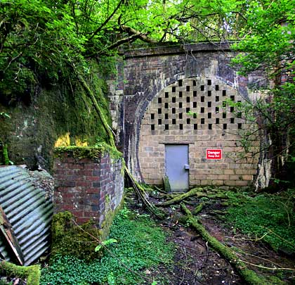
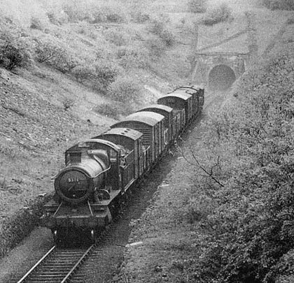
That last section demanded some major engineering works: a lengthy tunnel just north of Chipping Norton Station and two viaducts at Hook Norton. To the south of these was a shorter tunnel piercing the side of the Swere valley. Although officially known as Hook Norton Tunnel, it was located closer to Swerford Park, from which it derives its alternative name.
Preparatory work is thought to have begun in 1875, but this ceased in 1877 when the B&CDR ran into financial difficulties. Whilst the railway boundaries are marked on the 1881 map, construction did not start up again until 1883. The 1900 map records two discrete sets of earthworks above the tunnel line, indicative of constructions shafts having been sunk.
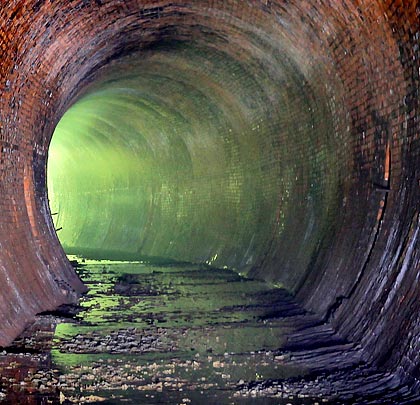
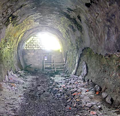
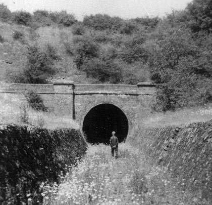
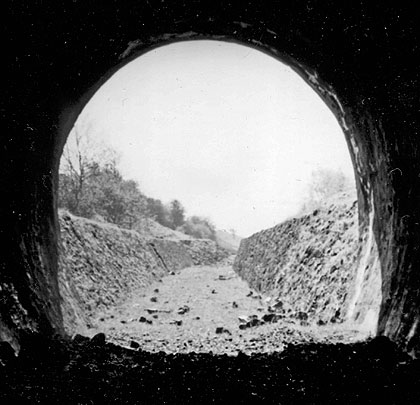
The gentle rise of the land hereabouts resulted in lengthy approach cuttings. Whilst these have shallow sides, near-vertical retaining walls were built adjacent to the track – these are around 7 feet high at the south end. The brick portal incorporated buttresses either side of the entrance and wing walls perpendicular to the track. The tunnel’s profile is effectively circular, framed by a lining of six brick rings.
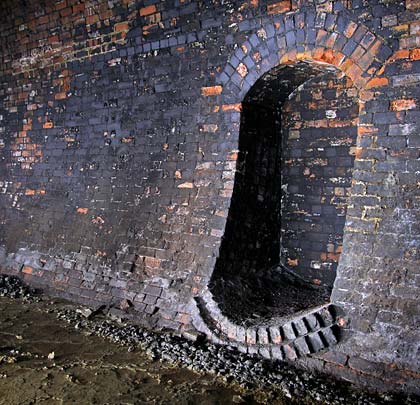
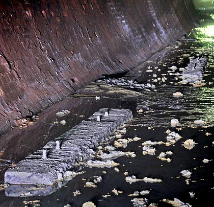
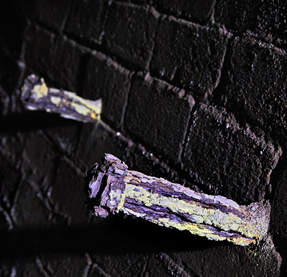
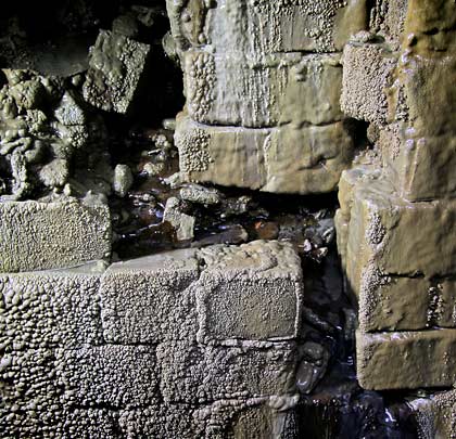
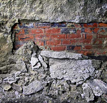
Extending for about 30 yards, spray concrete had been added for strengthening purposes. Much of this has fallen off since closure and what’s left is in a generally poor state. A hole has been cut into the west wall, allowing a spring to drain into the tunnel. The lining here is covered with mineral deposits. From this point northwards the tunnel is wet and muddy.
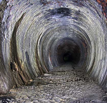
Built for a single track, Hook Norton Tunnel is 418 yards in length and incorporates a curve of approximately 52 chains in radius throughout. Refuges are built into both walls; some have deteriorating brickwork. Their backs are vertical, helping to emphasise the profile of the tunnel, which becomes more elliptical as the northern end is reached. It is reasonable to presume the presence of an invert.
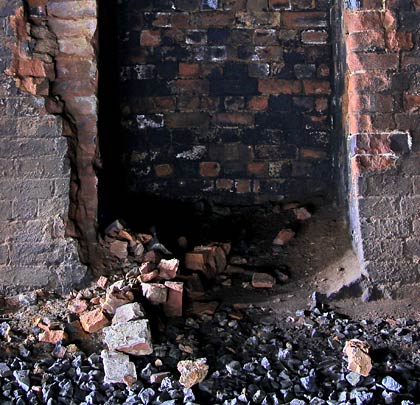
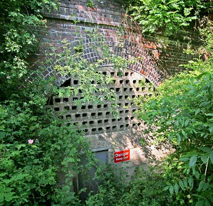
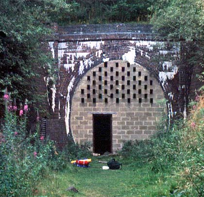
The north portal differs from its sibling in that its wing walls extend diagonally from the headwall. A permanent way cabin – now roofless – shelters beneath one of the them. The parapet and its copings have mostly been lost; the rest of the brickwork is blighted by vegetation.
Passenger services began their decline with the outbreak of World War II and several of the smaller stations closed in 1951. Goods traffic between Hook Norton and the Great Rollright Siding ceased on 30th September 1958 following a landslip in the northern approach cutting, bringing down the curtain on the tunnel’s operational history.