Goyden Pot Tunnel
Goyden Pot Tunnel
![The concrete south portal, though masked by trees, is more architecturally imposing than its north-west-facing sibling.](http://www.forgottenrelics.org/wp-content/uploads/2023/03/image1-128.jpg)
![A masonry block wall completely seals this end of the tunnel.](http://www.forgottenrelics.org/wp-content/uploads/2023/03/image2-128.jpg)
![Water ingress has locally carpeted the floor with calcite.](http://www.forgottenrelics.org/wp-content/uploads/2023/03/image3-128.jpg)
![The side walls are bare rock but a ledge has been cut into them to support a concrete roof arch. This runs continuously through the southern half of this 184(g) yard tunnel.](http://www.forgottenrelics.org/wp-content/uploads/2023/03/image4-127.jpg)
![In the northern section of tunnel, the concrete arches are discrete and were created with the help of wooden formers.](http://www.forgottenrelics.org/wp-content/uploads/2023/03/image5-127.jpg)
![Between each pair of arches, the roof is supported by a timber framework together with lengths of bullhead rail.](http://www.forgottenrelics.org/wp-content/uploads/2023/03/image6-125.jpg)
![The tunnel incorporates a tight curve of approximate 9 chains radius.](http://www.forgottenrelics.org/wp-content/uploads/2023/03/image7-121.jpg)
![Age and water have caused some of the wooden roof supports to perish, resulting in falls of rock from behind them.](http://www.forgottenrelics.org/wp-content/uploads/2023/03/image8-108.jpg)
![Looking into the gloom from the west portal, showing the discontinuous roof lining towards that end.](http://www.forgottenrelics.org/wp-content/uploads/2023/03/image9-93.jpg)
![Consumed by vegetation, the west portal is very unassuming.](http://www.forgottenrelics.org/wp-content/uploads/2023/03/image10-74.jpg)
![A foreman and labourer pose for the camera as work starts at the southern end of the tunnel.](http://www.forgottenrelics.org/wp-content/uploads/2023/03/image11-57.jpg)
![Following its completion in 1921, the tunnel accommodated trains heading up the valley whilst the original alignment was used by traffic travelling back down to Lofthouse.](http://www.forgottenrelics.org/wp-content/uploads/2023/03/image12-41.jpg)
![](http://www.forgottenrelics.org/wp-content/uploads/2023/03/image1-128.jpg)
![](http://www.forgottenrelics.org/wp-content/uploads/2023/03/image2-128.jpg)
![](http://www.forgottenrelics.org/wp-content/uploads/2023/03/image3-128.jpg)
![](http://www.forgottenrelics.org/wp-content/uploads/2023/03/image4-127.jpg)
![](http://www.forgottenrelics.org/wp-content/uploads/2023/03/image5-127.jpg)
![](http://www.forgottenrelics.org/wp-content/uploads/2023/03/image6-125.jpg)
![](http://www.forgottenrelics.org/wp-content/uploads/2023/03/image7-121.jpg)
![](http://www.forgottenrelics.org/wp-content/uploads/2023/03/image8-108.jpg)
![](http://www.forgottenrelics.org/wp-content/uploads/2023/03/image9-93.jpg)
![](http://www.forgottenrelics.org/wp-content/uploads/2023/03/image10-74.jpg)
![](http://www.forgottenrelics.org/wp-content/uploads/2023/03/image11-57.jpg)
![](http://www.forgottenrelics.org/wp-content/uploads/2023/03/image12-41.jpg)
Britain’s first municipal passenger railway was not built with people in mind. Instead it was laid to carry materials to Angram at the head of the Nidd Valley where Bradford Corporation was building a reservoir to satisfy the city’s thirst.
The route’s history dates back to 1901 when a Light Railway Order was granted for a 3-foot gauge line between Pateley Bridge and Lofthouse. At its northern end it met the contractor’s existing railway – which featured gradients as stiff as 1:40 – to form a route of almost 12 miles. The first sod was cut in July 1904.
In 1907, the Board of Trade gave its permission for the line to be converted to standard gauge and a connection was made to the North Eastern Railway’s Pateley Bridge branch, allowing the through running of works traffic. The line opened on 11th September 1907; the following day saw a passenger service inaugurated as far as Lofthouse to satisfy a requirement of the Order.
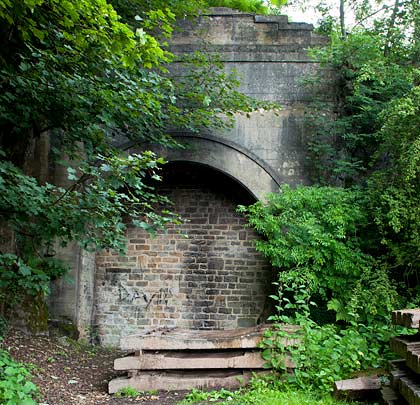
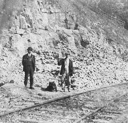
When the Angram reservoir was completed in 1919, attention turned to the building of a new dam at Scar House, 1½ miles further down the valley. Work started there in October 1921 and a largely self-sufficient village was established to accommodate the 1,250 construction workers. Over the intervening period, a tunnel was driven through the limestone to ease operational difficulties caused by a tight 90° curve at Goyden Pot where a passing loop was located. Its setting out proved problematic due to the tree-covered hillside above.
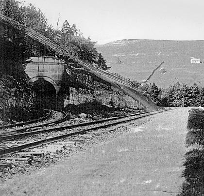
Entering it travelling northwards, uphill trains – often double-headed and with two bankers – left the 184-yard tunnel in a north-westerly direction, having encountered a curve of 9 chains in radius. The original alignment was used by downhill traffic returning to Lofthouse, with one of the passing loop lines retained for this purpose.
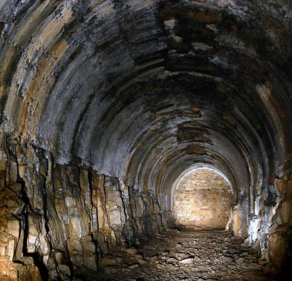
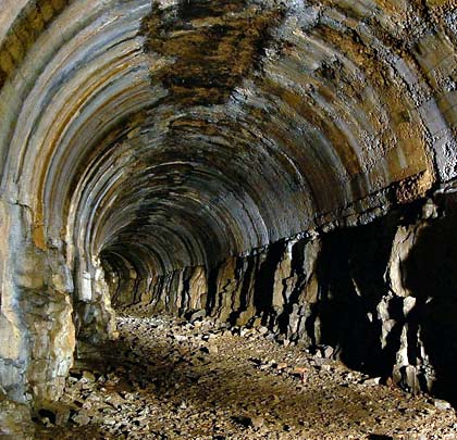
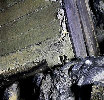
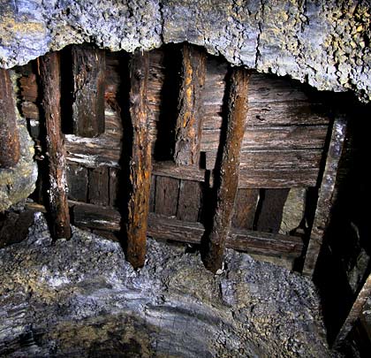
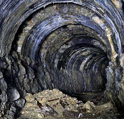
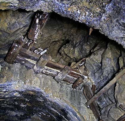
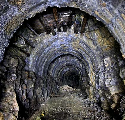
The southern portal is the more impressive of the two, both being built from concrete. The roof arch at that end is cast in concrete and sits on a shelf cut into the exposed rock side walls. Through the northern section, discrete arches are provided – each about 8 feet wide – with the intervening gaps featuring frameworks of timber and rail to arrest any loose material. A short and shallow cutting retreats from the furthest portal as the track curves to adopt a westerly heading.
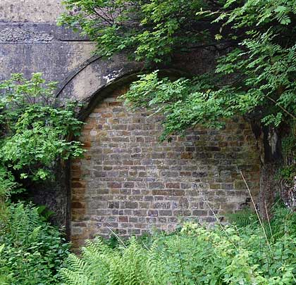
Passenger services to Lofthouse were withdrawn at the end of 1929 though works traffic continued to use the line until 1936. Within a year, it had been dismantled. The tunnel, now bricked-up at both ends, remains mostly dry inside. The timber roof supports are deteriorating due to water ingress, causing a couple of them to fail. Small falls of rock have occurred and there has been one larger collapse near the north entrance.