


The Swadlincote Loop
The Swadlincote Loop
The town of Swadlincote is situated in the southern tip of Derbyshire, about 15 miles south of Derby and five miles east of the Staffordshire brewery town of Burton-on-Trent. Geographically it lies in a valley with hills on three sides and an open aspect facing west. The area was rich in coal and clay deposits which attracted a considerable amount of industry. Indeed by the end of the 19th century it is believed that, with an annual output of over three million tons, coal production in Leicestershire and South Derbyshire accounted for just over 1% of national coal production.
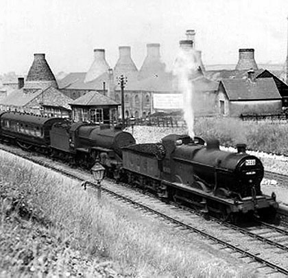
At various times, from the beginning of the 19th century until the demise of the coal industry in the 1980s, there have been around 60 brick and pipe yards – often with adjacent clay pits – and 15 large collieries in the Swadlincote area. The skyline was full of colliery head stocks, bottle kilns and giant chimneys belching smoke. Amongst all the industry was an elaborate system of railways – mostly standard gauge but with narrow gauge tracks to serve the pits and clay holes. For a time there was even a 3’6” gauge tramway which wound its way through the industrial landscape.
hoto: Magic Attic (Swadlincote)
The first railway to reach the area was the Swadlincote Railway, instigated in 1826 and completed the following year. The line ran for three miles from Overseal Spring Cottage to Wideshaft Pit via Gresley Common. It is believed that this railway was built to a gauge of 4’2” with the rails being fastened into stone blocks set in the ground. In 1833, six years after the completion of the horse-drawn Swadlincote Railway, the Leicester to Swannington railway opened, the first local line to use steam locomotives. Like the earlier line, it ran from a canal – in this case the River Soar Navigation – to an industrial area rich with mineral deposits.
The next arrival was the Birmingham & Derby Junction Railway, running between the places in its title and putting Burton-on-Trent on the railway map. At Derby, the B&DJR met two other railways – the Midland Counties and the North Midland. All three companies amalgamated in 1844 to form the Midland Railway.
In 1845 the Midland took over the Leicester & Swannington Railway and the Ashby Canal, with a view to converting the latter into a railway. In 1848 the Leicester and Swannington line was extended by the Midland through South Derbyshire to Burton-on-Trent, whilst at the Leicester end the line was extended and improved to connect with the former Midland Counties Railway. It is from the Burton to Leicester line that the Swadlincote loop left and rejoined after a circuitous route of just over seven miles which it took in some of the most heavily industrialised areas of South Derbyshire.
Origins and development
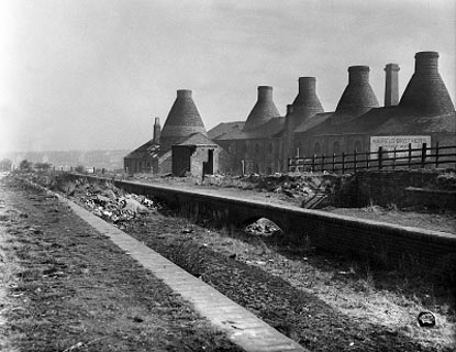
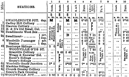
The Swadlincote loop had its origins from two quite independent branches off the Burton to Leicester line. The first section to consider is that from Swadlincote Junction to Swadlincote. This section was authorised under the Midland Railway (Leicester and Swannington Alteration) Act of 1846 and although recorded as opening to passengers in 1851 much of the line had been completed by as early as September 1849. There were several collieries on the stretch of land from Cadley Hill to Swadlincote and apart from the curve from the junction with the main line the rest of the branch into Swadlincote was completely straight, a distance of just under two miles. A siding for Hall and Boardman’s at Swadlincote was the first off the branch, opened in 1852 with a second being added in 1854.
Throughout its entire history, the line was affected by mining subsidence with this first being recorded as early as 1857 when the Midland Railway was offered the purchase of the unmined seams to maintain the level of the line. The company declined the offer, instead choosing to monitor the track and maintain a supply of ballast at Swadlincote so that it could be raised when subsidence occurred. Passenger services to Swadlincote were withdrawn in October 1853 and the line was purely a coal and pottery branch until their reintroduction on 1st June 1864.
During the period covered so far, a second branch from the Leicester to Burton line was constructed to Wooden Box. Authorised by the Midland Railway (Burton-upon-Trent to Nuneaton Act) 1846, this line ran from its junction with the main line through Swains Park and the Gresley and Albert Village districts to a terminus just beyond the Ashby to Burton turnpike road at Wooden Box. It remained in use as Wooden Box until it was renamed Woodville on 1st October 1868.
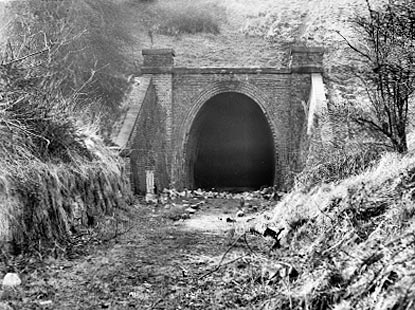
Photo: Magic Attic (Swadlincote)
The line to Woodville was opened to goods traffic as early as 1850; however like its neighbour, the Swadlincote branch, the line was also closed for a period between 1st October 1856 and 1st April 1859 when a passenger service was also started. Over the years, feeder branches were constructed to serve the numerous industries which had developed in the area, the most notable of which served Granville and Church Gresley collieries, John Knowles pipe yard and T G Green’s pottery.
It was not until the 1870s that it was decided to join the Swadlincote and Woodville branches together, thus making it a through route from Burton to Leicester. The Midland Railway (Additional Powers) Act 1875 (Woodville to Swadlincote) authorised the construction of the line. Originally it was intended that the loop would join the two existing termini but the lie of the land made this impractical. Even as built, the steep climb from Swadlincote to Woodville presented many problems which often necessitated the double-heading of most heavy trains over the loop.
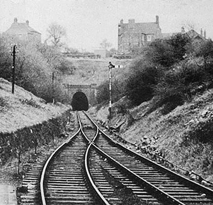
A Swadlincote and Woodville Construction Committee was formed in 1875 to supervise the construction of the line. Its course involved two tunnels, the first at Midway (104 yards) and the second at Woodville (307 yards), both of which were required to take the line beneath the Burton to Ashby turnpike, as well as numerous cuttings and embankments to overcome the landscape’s undulations.
This alignment demanded the construction of a new station at Woodville. Originally, the Midland Railway had intended to build it immediately to the south of Hartshorne Road. However, this proposal enraged the inhabitants of Woodville who felt that the location better served the neighbouring village of Hartshorne rather than their own, so much so that the Midland were petitioned on the subject. Not wanting to be seen as insensitive to local inhabitants, the Midland chose a more central site for the station approximately a quarter of a mile further south.
Photo: Simon Swain
Work on the new line commenced in 1880 and by the end of that year there were reported to be 257 men, 18 horses and three engines engaged on the construction. By December 1881 only one of the portals to Woodville Tunnel remained unfinished but, elsewhere, numerous slips in the cuttings and on the embankments hindered progress. By September 1882 it was reported that the line had been laid in its entirety and the contractor was finishing off. New stations were built at Swadlincote and Woodville, the structures at each being identical. The typical Midland Railway brick main buildings were on the town side with wooden waiting rooms provided on the opposite platforms. The line was single track throughout, with loops provided at the stations to enable trains to pass.
The Midland Railway took possession of the extension from the contractor on 1st January 1883 with passenger services over the loop commencing on 1st May. The extension from the new station at Woodville to the junction with the original Woodville Goods branch opened on 1st September 1884. Upon completion of the new line the earlier Woodville terminus became a goods depot, the separate route often being referred to as ‘The Old Road’.
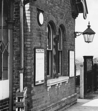
Photo: Simon Swain collection
The route described
The best place to start a description of the loop line is at its northern end. Shortly after diverging from the Derby to Birmingham railway, the Burton-on-Trent to Leicester line crosses the River Trent and its washlands on the 16-arch Stapenhill Viaduct, passing thus into Derbyshire. On the right were the grounds of Drakelow Hall, the ancestral home of the Gresley family, one of whose descendants, Sir Nigel Gresley, was to achieve fame as the designer of the A4 Pacific ‘Mallard’, holder of the world speed record for a steam locomotive. In the 1950s a massive power station was constructed in the grounds which proved to be a major source of freight traffic for the Leicester line.
After passing beneath the road to Stanton House, the first junction reached was Bretby Junction where the branch to Bretby Colliery diverged – the divergence of traffic here being controlled by a signal box between 1868 and 1952, after which traffic was controlled by a ground frame. The branch was constructed by the Midland Railway and opened on 1st October 1868. It was operated on a ‘one engine in steam’ principle and had a speed limit of 15mph.
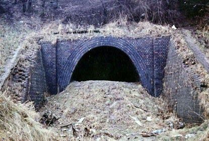
Photo: Ian Gill
Forsaking the journey over the loop for a while, it is necessary to explore this 2½-mile branch which climbed north-eastwards through a cutting before passing beneath the present day A444 at Stanton, beyond which it diverged into two. The first branch on the right led to Bretby No.3 (or Stanton) pit and to Lakes Brickyard. A second branch, a short distance further on, made a trailing connection on the same side. Engines visiting the pit or brickyard would stop after the second junction and reverse up the branch, less severely graded than the southerly connection, but would leave by the steeper link.
The main branch continued past the Klondyke Brickyard and passed under the present day A511, just to the west of the Stanhope Arms, to reach Bretby Coal Wharf. A wooden platform was erected here for the benefit of the Earl of Caernarvon and his guests to alight when the occasional special train ventured up the branch for a shooting weekend at nearby Bretby Hall.
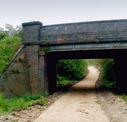
The colliery at Bretby closed in July 1960 to be replaced by a drift mine which was to close just six years later. The Bretby Colliery branch was officially closed on 1st June 1963 but was used until August 1968 for wagon storage. Today the site of the colliery has been totally cleared, although the winding house remains adjacent to Park Road. The course of the branch, although substantially overgrown, can still be discerned and the bridges over the A444 and A511 remain, complete with British Railways Board structure numbers.
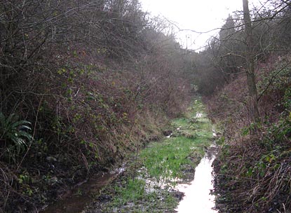
Photo: Simon Swain
Returning to the loop itself, this diverged approximately 500 yards beyond Bretby Junction at Swadlincote Junction which was controlled a 25-lever box. From here the line struck out in an easterly direction to shortly pass beneath the A444. In the early 1960s, an extensive marshalling yard was constructed when Cadley Hill Colliery was modernised. The old brick-built bridge was replaced by a concrete structure, a second span being required to cross the line into the colliery. Cadley Hill Colliery was sunk by Hall and Boardman in 1860 and was one of the last in South Derbyshire to close in March 1988. It was noteworthy as it was one of the last NCB collieries to use steam as motive power.
Once past Cadley Hill the line was surrounded by further industry. To the left was Hallfield’s pipe yard and the long disused Nadin’s colliery. A footpath to the right of the line followed the course of a branch line which once led to another colliery at Gresley Wood and a little further along was the site where, in the 1960s, the NCB built a test track for its underground locomotives. Beyond here was Swadlincote Colliery which closed in 1965. These two pits were once connected by a 1’11” narrow gauge railway running parallel to the loop.
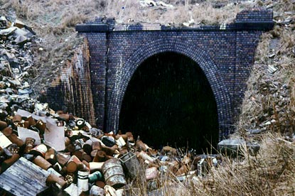
Photo: Ian Gill
Before entering the station at Swadlincote, the line crossed Darklands Road by means of a gated level crossing. Immediately prior to entering the station there were two sidings which diverged to the right. The first one served Ault’s Pottery, prior to this it had also served Cartwright’s Colliery which had closed as early as 1906. The second siding served Rowley’s Pottery which was situated adjacent to the station.
The station at Swadlincote was a simple affair, built to a standard Midland design consisting of two opposite platforms. The main buildings were situated on the Up side with a basic wooden shelter being provided on the Down. Passenger access to the station was via a driveway off Midland Road. In 1890 a footbridge was constructed at a cost of £250 to allow passengers to cross between platforms. This was removed around 1905 when Midland Road was bridged over the line to carry the Burton & Ashby Light Railway. At the same time the original road, which had crossed the line by a level crossing at the eastern end of the station, was renamed Lower Midland Road. From this point onwards access between the platforms was either by foot crossings at the end of the platforms or, in the case of the Down platform, via a path which descended from Midland Road.
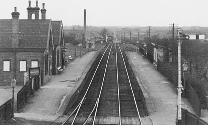
Photo: Simon Swain collection
Leaving Swadlincote the line immediately passed beneath Midland Road. To the left of the line was the tram depot for the Burton & Ashby Light Railway. After the trams stopped running in 1927, these premises were to become the NCB central workshops. To the right was Swadlincote goods yard which was built on the site of the original Swadlincote terminus. The sidings of the yard extended some distance to the right across Belmont Street to the town’s gas works. The yard possessed two rail-mounted hand cranes for container traffic from the adjacent potteries. In pre-grouping days, the London & North Western Railway also had a goods office here.
Immediately beyond the yard the Wragg’s and Woodward’s industrial branch diverged right to cross Belmont Street on the level before passing beneath Church Street and continuing along in a deep cutting to reach the first pipe yard. So far this branch has followed the course of the old Swadlincote Railway but then deviated to pass beneath Hill Street before crossing Coppice Side on the level to enter the second pipe yard. Due to the steep gradients on this branch, a maximum of six wagons were allowed to be pushed up the gradient to guard against runaways. A large earth-filled stop block was built near to Belmont Street to cater for such eventualities.
Returning to the loop itself, the line passed beneath Midway Road and began a climb on a gradient of 1:40 through a deep cutting to pass beneath the present day A50 via the 104-yard Midway Tunnel. Numerous trains stalled on this gradient. On one occasion a locomotive failed in Midway Tunnel and had to be backed all the way to Swadlincote to take another run at it. On another occasion it is reported that a local freight took an hour to cover the two miles from Swadlincote to Woodville! After emerging from the tunnel, the line continued on an embankment to cross Hartshorne Road on a single-span red brick bridge. A short distance onwards the station at Woodville was reached.
Woodville Station was identical to Swadlincote in nearly every respect. Again the main buildings were located on the Up side, with only basic waiting facilities being provided on the Down. An unusual feature about the station was that the signal box was located on the Down platform. Access to the station was via Station Road and passengers always had to cross between platforms on board crossings situated at the west end of the station, no footbridge ever being provided. Behind the Down platform was a siding which served Mansfield Brothers sanitaryware works.
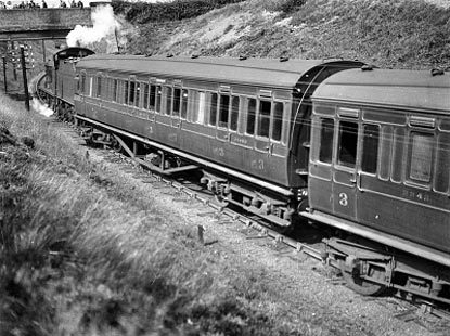
Photo: Magic Attic (Swadlincote)
Upon leaving the station at Woodville, the line continued in a cutting for a short distance to pass beneath the Burton to Ashby road through the 307-yard Woodville tunnel. Emerging from the tunnel the line then passed the Woodville Sanitary pipe works and Albion Clay Company before passing beneath the Woodville to Moira road and then on an embankment to cross the Woodville to Albert Village road by means of a two-span steel bridge with brick abutments. Continuing down the embankment, the Woodville Goods branch joined from the right.
Like most of the goods branches, it was worked on the ‘one engine in steam’ principle and had a 15mph speed limit. On the way to the good station was a branch which diverged to the left to Granville Colliery and which also served Greens Hilltop works via a reversal and a steep climb. Granville Colliery had a particularly high output and its own internal shunting locos. Coming into the goods branch from the right was another branch from The Mount Pleasant Works. The company had an extensive standard gauge system; a signal box and crossing gates were provided where this branch crossed the Woodville to Albert Village road.
In the sidings for both branches was a run-around loop where freight trains bound for Woodville Goods would run round to the rear of their trains. From here the loco would push the wagons under the bridges of Swadlincote Road (A514) and Burton Road (A50) to the terminus of the line. After emerging from beneath the A50, the single line split into four sidings with the old station buildings, the goods shed and stable block to the right. The siding to the extreme right extended beyond the station and then curved through 90 degrees to the left to reach C W Outram’s Excelsior Pottery. The terminus at Woodville Goods was unusual in that there were no proper running round facilities without going through the goods shed, which was not permitted!
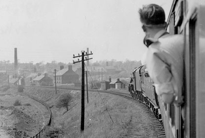
Photo: Simon Swain collection
Returning to the loop line itself, the track passed over the A586 on a steel girder bridge soon after passing Woodville Goods Junction. As the line curved, a pair of sidings joined from the right which served Woodward’s Pipe Yard and Wragg’s Iron Foundry. Soon afterwards a vast expanse of sidings was reached serving the Gresley Colliery branch and Mansfield’s Pipe Yard. This branch was very steep and, like the other freight branches, had a 15mph speed limit. A noteworthy feature of this branch was that it curved sharply and continuously to the left finishing on top of an enormous spoil heap. The rails here were laid on steel sleepers rather than wooden ones as the bank was forever smouldering due to spontaneous combustion.
Once more returning to the loop, the line then crossed the Albert Village to Linton Road by means of Swain’s Park level crossing. With Moore’s Pipe Yard to the right, the line then descended to join the Burton to Leicester line.
For purposes of clarity and completion we will continue a little further along the Leicester line to explore the Moira junctions which are a prominent feature of the area’s railway history. Beyond the junction connections there were sidings either side of the Burton to Leicester line which served numerous pipe works. After passing beneath a blue-brick bridge carrying the road to Overseal, the main Burton to Leicester line branches diverged both to the left and right. The latter ran to serve Rawdon and Marquis collieries. Both of these were owned by the Moira Colliery Company which also owned Gresley Colliery. The line which ran to the right was the west curve of the triangular Moira junction and ran to Nuneaton via Shackerstone and Market Bosworth. It was jointly operated by the Midland and London & North Western Railway companies. This line lost its regular passenger services as early as 13th April 1931; however the large collieries at Donisthorpe and Measham ensured the line’s survival well into British Railways days.
Operational history, decline and closure
The Swadlincote Loop line ran through one of the most densely industrialised areas of South Derbyshire and as such freight services were always more predominant than passenger services. As we have seen, branches off the loop ran to serve individual collieries as well as pipe yards, potteries and clay pits. All of these branches generated their own traffic which then fed onto the loop line for transportation to destinations further afield.
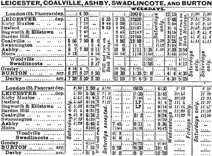
A study of the working timetables for the period immediately prior to 1914 would appear to show that passenger workings were scheduled to run between freight workings – an indication that the former were of secondary concern. Throughout this period there were generally five passenger workings in the Down direction with six in the Up, usually consisting of two morning services, two afternoon services and one in the evening. Those in the Down direction all originated from Burton-on-Trent and either terminated at Ashby or Coalville, with only the occasional service running all the way through to Leicester. There was also one local return working from Burton to Woodville and back. Those services in the Up direction all originated from Ashby and Coalville and terminated at Burton. There is no evidence to suggest that there were ever any timetabled Sunday services. Therefore passengers wishing to travel to Leicester from Swadlincote and Woodville would either have to travel along the loop to Burton or Ashby and change trains for Leicester.
Simon Swain collection
The lack of success of the Swadlincote Loop for passenger traffic is a little surprising, although line occupation was dominated by heavy freight traffic. The Burton & Ashby Light Railway, which was opened in 1906 and owned by the Midland Railway Company, was effectively running in competition with the trains. The tramway ran for 11½ miles from Burton-on-Trent through Swadlincote and Woodville to Ashby at ten minute intervals. One wonders why the tramway was built when local train services could have been improved by the provision of convenient halts and the introduction of a steam rail motor service, something the Midland often did with local branch services.
The period following the First World War saw the slow and terminal decline of passenger services over the loop. It is not surprising that the trams were the first casualty of this public transport rationalisation. Services between Ashby and Burton via Swadlincote and Woodville were withdrawn on 19th February 1927. Passenger services over the loop, which had never been either frequent or well timed, were gradually wound down until the service consisted of just one train in each direction. With this level of service, closure to passengers was inevitable and this came on 6th October 1947.
After this date a great variety of excursion traffic continued to use the loop. The most regular special workings were those to Derby County football matches which ran outward on Saturday lunchtimes or midweek evenings throughout the season, returning after the final whistle. Other frequent specials included a late Friday night holiday train to Blackpool during the summer months, with the return working mid-afternoon Saturday, often producing a pair of engines at the head of the train; on some occasions named locomotives were seen. Theatre trips, Sunday School outings and day trips to Skegness and Alton Towers were some of the other excursion destinations.
Simon Swain collection
During this period the loop would occasionally be used for Burton to Leicester services diverted off the main line near Gresley. The section of line between Swadlincote and Woodville junctions was prone to be affected by significant mining subsidence and the loop was a useful diversionary route when remedial work was required. Sadly, the line closed to these remaining passenger services on 8th September 1962.
Following the cessation of regular passenger services in October 1947, freight traffic remained strong for a number of years; however, by the late 1950s, local traffic had begun to diminish and, as the 50s became the 60s, rationalisation was at the heart of both British Railways and local industry. Many of the pipe yards had closed and those remaining transferred their output to road traffic. For its last few operational months, the Swadlincote Loop reverted to its origins, being worked as two separate branches due to the closure of Woodville Tunnel owing to fears over the structure’s safety. The inevitable closure came on 2nd March 1964 and with it the end of over 100 years of operation.
The route today
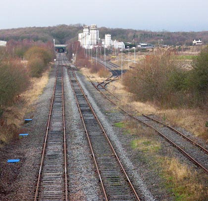
Following its closure, the Swadlincote Loop metals remained in situ for over 12 months before the dismantling crew arrived; however by the end of 1965 all the track had been lifted apart from the short section from Swadlincote Junction to Cadley Hill which was retained for the colliery. In the years that have followed, nearly all of the industry that generated so much traffic for the loop has disappeared and its course has been encroached upon in a number of locations to the extent that now only a few sections of it survive. Unless one knew that a railway had once run through the area it would be difficult to imagine that it had done so.
As we have previously mentioned, the junction with the main Burton to Leicester line remains in situ, albeit extremely overgrown. From this point it is also possible to discern the remains of the embankment of the Bretby colliery branch which left the main line just a few hundred yards before Swadlincote Junction. The track remains in situ for approximately half a mile to the site of the exchange sidings which once served Cadley Hill Colliery and the bridge carrying the A444 over the line also remains.
Beyond here the trackbed has been completely obliterated by a combination of opencast mining and the development of heavy industry. Very little remains of the route until the outskirts of Swadlincote are reached. A public footpath runs parallel to its course for a short distance on the approach to the site of the crossing at Darklands Road; however immediately beyond this crossing a modern housing development has been built over the route.
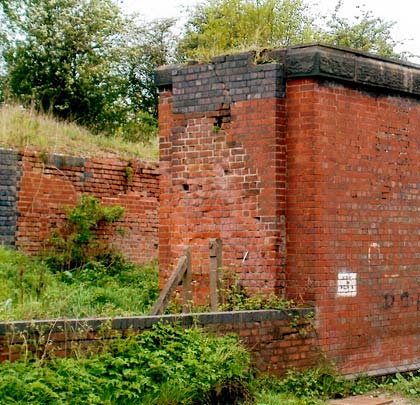
Of Swadlincote Station very little remains apart from a small section of the Burton platform; however the substantial blue brick bridge – constructed to take Midland Road over the line – is still extant. The site of the goods yard at Swadlincote has now been redeveloped as a small retail complex although the goods shed and offices were still there in the 1980s. On Belmont Street there remains one of the concrete posts which marked the site of where the branch to Wragg’s & Woodward’s pipe works crossed the street.
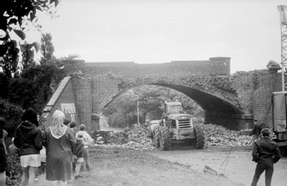
Photo: Magic Attic (Swadlincote)
From Swadlincote a majority of the line’s course has been lost until Hartshorne Road is reached. From here it is possible to reach the trackbed and walk as far as the site of Woodville Station, of which nothing remains. Beyond it is possible to trace the course of the line as it headed towards Woodville Tunnel. The next point of access is the extant bridge which carried Moira Road over the railway; a public footpath follows the route before deviating to serve a new housing complex. It is still possible to see the densely overgrown embankment as the formation makes it way towards Occupation Lane. Here the red brick parapets of the bridge that took the railway over the road remain, complete with its British Railways Board structure number.
The course of the line is again lost until Bridge Street in Albert Village. Here it is still possible to see where the line would have crossed the road, although no trace of this bridge exists. As the line headed towards Woodville Junction, its course has been utilised for recreational purposes and a network of footpaths have been made for leisure use as this area now forms part of the National Forest. One of them leaves the trackbed at approximately the same location as the Gresley Colliery branch would have done and it is possible to follow this route as far as the site of the colliery, today used by a local haulage firm. Until quite recently remnants of rails could still be seen in the yard, but these have now gone.
Returning to the loop line, the footpath follows its course as far as Swains Park crossing where the line crossed Occupation Lane and recently another footpath has been constructed along the trackbed as far as Woodville Junction itself. The 1990s saw the construction of an opencast coal screening plant which significantly changed the track layout at this site; the junction itself was lost. Today the Burton to Leicester line remains in use for occasional freight traffic, however even this has been greatly reduced in recent years.
© Simon Swain 2012
(Track diagram based on 1923 OS Map)
 November 2012