Podgill Viaduct
Podgill Viaduct
![Opened in 1861, this is Podgill's north-western elevation featuring the original single track viaduct.](http://www.forgottenrelics.org/wp-content/uploads/2023/03/image1-359.jpg)
![When the route was doubled-track between 1889-92, a second structure was erected alongside the original and tied into it.](http://www.forgottenrelics.org/wp-content/uploads/2023/03/image2-359.jpg)
![Podgill is now owned and maintained by the Northern Viaduct Trust.](http://www.forgottenrelics.org/wp-content/uploads/2023/03/image3-359.jpg)
![Each of its 11 semi-circular arches has a span of 30 feet.](http://www.forgottenrelics.org/wp-content/uploads/2023/03/image4-356.jpg)
![Refuges were created by removing sections of the parapet wall and inserting cast iron plates.](http://www.forgottenrelics.org/wp-content/uploads/2023/03/image5-349.jpg)
![Both abutments feature pilasters, topped by monumental stones which are pyramid-shaped at their tops.](http://www.forgottenrelics.org/wp-content/uploads/2023/03/image6-335.jpg)
![The structure's deck reaches 84 feet above Ladthwaite Beck.](http://www.forgottenrelics.org/wp-content/uploads/2023/03/image7-313.jpg)
![The south-east side, showing the widened section of viaduct.](http://www.forgottenrelics.org/wp-content/uploads/2023/03/image8-270.jpg)
![Assisted by a rail-mounted steam crane on a trestle bridge, apron-clad masons work to widen Podgill for its second track.](http://www.forgottenrelics.org/wp-content/uploads/2023/03/image9-217.jpg)
![](http://www.forgottenrelics.org/wp-content/uploads/2023/03/image1-359.jpg)
![](http://www.forgottenrelics.org/wp-content/uploads/2023/03/image2-359.jpg)
![](http://www.forgottenrelics.org/wp-content/uploads/2023/03/image3-359.jpg)
![](http://www.forgottenrelics.org/wp-content/uploads/2023/03/image4-356.jpg)
![](http://www.forgottenrelics.org/wp-content/uploads/2023/03/image5-349.jpg)
![](http://www.forgottenrelics.org/wp-content/uploads/2023/03/image6-335.jpg)
![](http://www.forgottenrelics.org/wp-content/uploads/2023/03/image7-313.jpg)
![](http://www.forgottenrelics.org/wp-content/uploads/2023/03/image8-270.jpg)
![](http://www.forgottenrelics.org/wp-content/uploads/2023/03/image9-217.jpg)
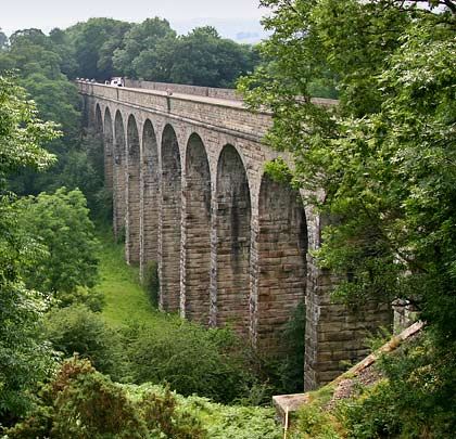
The South Durham & Lancashire Union Railway fought its way over Stainmore Summit, 1,370 feet above sea level. Opened on 4th July 1861 as a single-track route, the steep western descent into Kirkby Stephen took it over three masonry viaducts – Hatygill, Merrygill and Podgill – all engineered by Sir Thomas Bouch.
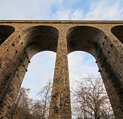
The latter of these was the most substantial, with 11 arches each 30 feet in span. It conveyed the line across Ladthwaite Beck for a distance of 155 yards, reaching 84 feet high at its peak.
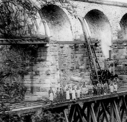
Built by contractor Chambers & Hilton for £6,189, the inside faces of the piers still have projecting stones at the top, used to support the timber centering for construction of the arches.
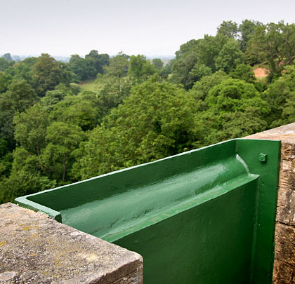
The route was an immediate success and, during the 1880s, was hauling a million tonnes of coke annually to Cumbria’s coastal blast furnesses. Between 1889-92, to satisfy this demand, a second line was added to carry westbound trains. This involved building a second viaduct to the south side of the first, then tying the two together. The complete structure is 25’7″ wide.
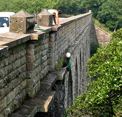
Seven sections of parapet were removed to create refuges, with cast iron plates inserted flush with the outer edge of the stonework. Both abutments feature pilasters, topped by monumental stones cut into pyramid shapes.
The through route closed in 1962 but a short section survived until 1975 to serve Hartley Quarry – this involving crossing Podgill Viaduct.
The structure – now Grade II listed – was acquired by the Northern Viaduct Trust in 2000. A restoration programme was initiated which involved repairs to the masonry, waterproofing of the deck and raising its surface by 300mm. It now forms part of the Trust’s ‘railway trail’.