Monmouth Viaduct & river bridge
![The south side of the masonry structure is still in fair condition.](http://www.forgottenrelics.org/wp-content/uploads/2023/03/image1-341.jpg)
![Parts of the spandrels and several voussoir stones are missing from the northern face of the viaduct.](http://www.forgottenrelics.org/wp-content/uploads/2023/03/image2-341.jpg)
![Both abutments for the lost iron river span are also the worse for wear.](http://www.forgottenrelics.org/wp-content/uploads/2023/03/image3-341.jpg)
![This pier is having to withstand considerable forces exerted by the 20 arches beyond it.](http://www.forgottenrelics.org/wp-content/uploads/2023/03/image4-338.jpg)
![Further north, the river bridge - approached from the south via an embankment - remains in place.](http://www.forgottenrelics.org/wp-content/uploads/2023/03/image5-332.jpg)
![The deck is due to be converted to accommodate feet and wheels.](http://www.forgottenrelics.org/wp-content/uploads/2023/03/image6-319.jpg)
![The structure is clearly in need of a repaint.](http://www.forgottenrelics.org/wp-content/uploads/2023/03/image7-298.jpg)
![Local carpenter James Edwards, pictured around 1910 with the viaduct's iron river span as a backdrop.](http://www.forgottenrelics.org/wp-content/uploads/2023/03/image8-256.jpg)
![A classic aerial view showing the converging structures on their approach to Monmouth Troy, out of shot on the right.](http://www.forgottenrelics.org/wp-content/uploads/2023/03/image9-207.jpg)
![](http://www.forgottenrelics.org/wp-content/uploads/2023/03/image1-341.jpg)
![](http://www.forgottenrelics.org/wp-content/uploads/2023/03/image2-341.jpg)
![](http://www.forgottenrelics.org/wp-content/uploads/2023/03/image3-341.jpg)
![](http://www.forgottenrelics.org/wp-content/uploads/2023/03/image4-338.jpg)
![](http://www.forgottenrelics.org/wp-content/uploads/2023/03/image5-332.jpg)
![](http://www.forgottenrelics.org/wp-content/uploads/2023/03/image6-319.jpg)
![](http://www.forgottenrelics.org/wp-content/uploads/2023/03/image7-298.jpg)
![](http://www.forgottenrelics.org/wp-content/uploads/2023/03/image8-256.jpg)
![](http://www.forgottenrelics.org/wp-content/uploads/2023/03/image9-207.jpg)
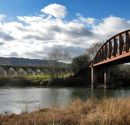
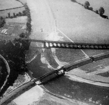
The River Wye flows to the east side of Monmouth, creating significant challenges for the engineers charged with connecting the town to the rail network back in the 19th century.
The Coleford, Monmouth, Usk & Pontypool Railway approached from the south-west in 1857, terminating at Monmouth Troy. Four years later, the line was extended to Wyesham, around a mile further east, by means of a single-span girder crossing of the river with a 20-arch approach viaduct in red sandstone on its west side. Two more arches carried the line to higher ground from the river span’s eastern abutment. Collectively these structures were known as Monmouth Viaduct.
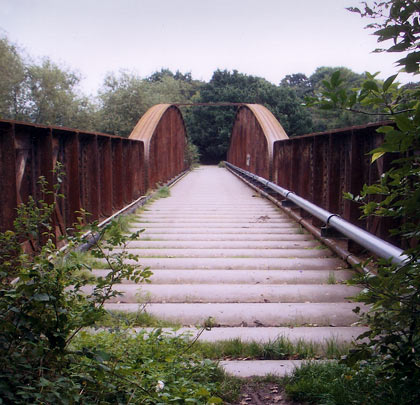
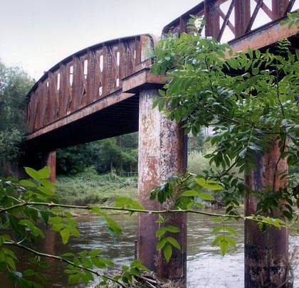
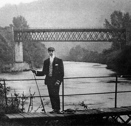
In 1873, the Ross & Monmouth Railway arrived from the north-east at Monmouth May Hill. Connecting the town’s two terminii – thereby creating a through route – demanded a ¾-mile link and another bridge, this time a three-span wrought iron structure almost 300 feet in length, with a bowstring central section. A lengthy embankment at its southern end ensured trains didn’t get their wheels wet. It opened on 1st May 1874.
By 1959, the only route left into the town was up the picturesque Wye Valley – this had made an end-on junction with the CMU&P at Wyesham in 1876. Both bridges remained in service, allowing freight trains from Troy to reach May Hill. But the line was closed completely on 6th January 1964.
The viaduct’s river span has been removed and its masonry arches – particularly on their northern side – have suffered marked deterioration. The river bridge is still standing and, despite its rust, is due to provide a link for pedestrians and cyclists as part of a Sustrans scheme.
(Gareth James’ photos are used under this Creative Commons licence.)