Glen Ogle Viaduct
Glen Ogle Viaduct
![The line clings to the west side of Glen Ogle, but engineers were forced to erect a 12-arch viaduct to cross a depression in the land.](http://www.forgottenrelics.org/wp-content/uploads/2023/03/image1-302.jpg)
![Stone projections are still apparent at springing level, used to support the timber centring needed for construction of the arches.](http://www.forgottenrelics.org/wp-content/uploads/2023/03/image2-302.jpg)
![Built from rubble-faced stone, the structure incorporates a curve to the east at its southern end.](http://www.forgottenrelics.org/wp-content/uploads/2023/03/image3-302.jpg)
![A refuge was built above one of the piers; the west-side parapet to the south of this has been lost.](http://www.forgottenrelics.org/wp-content/uploads/2023/03/image4-299.jpg)
![The view north, in the direction of Crianlarich.](http://www.forgottenrelics.org/wp-content/uploads/2023/03/image5-294.jpg)
![Today, with handrails installed, the viaduct forms part of a footpath.](http://www.forgottenrelics.org/wp-content/uploads/2023/03/image6-284.jpg)
![From the parallel road that climbs through the glen, it becomes clear just how high the viaduct is up the valley side.](http://www.forgottenrelics.org/wp-content/uploads/2023/03/image7-266.jpg)
![Time and weather has caused this lone telegraph pole, with some insulator pots still intact, to adopt a more relaxed approach.](http://www.forgottenrelics.org/wp-content/uploads/2023/03/image8-230.jpg)
![To the south of the main viaduct is a smaller structure of three spans.](http://www.forgottenrelics.org/wp-content/uploads/2023/03/image9-189.jpg)
![A fabulous aerial view of the viaduct, bathed in autumn sunshine.](http://www.forgottenrelics.org/wp-content/uploads/2023/03/image10-134.jpg)
![In the summer of 1956, the 09:18 out of Oban enjoys the falling gradient as it heads south across the viaduct.](http://www.forgottenrelics.org/wp-content/uploads/2023/03/image11-111.jpg)
![](http://www.forgottenrelics.org/wp-content/uploads/2023/03/image1-302.jpg)
![](http://www.forgottenrelics.org/wp-content/uploads/2023/03/image2-302.jpg)
![](http://www.forgottenrelics.org/wp-content/uploads/2023/03/image3-302.jpg)
![](http://www.forgottenrelics.org/wp-content/uploads/2023/03/image4-299.jpg)
![](http://www.forgottenrelics.org/wp-content/uploads/2023/03/image5-294.jpg)
![](http://www.forgottenrelics.org/wp-content/uploads/2023/03/image6-284.jpg)
![](http://www.forgottenrelics.org/wp-content/uploads/2023/03/image7-266.jpg)
![](http://www.forgottenrelics.org/wp-content/uploads/2023/03/image8-230.jpg)
![](http://www.forgottenrelics.org/wp-content/uploads/2023/03/image9-189.jpg)
![](http://www.forgottenrelics.org/wp-content/uploads/2023/03/image10-134.jpg)
![](http://www.forgottenrelics.org/wp-content/uploads/2023/03/image11-111.jpg)
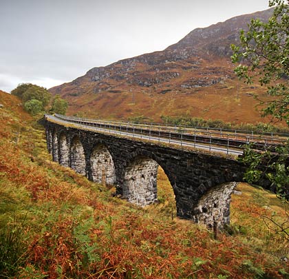
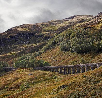
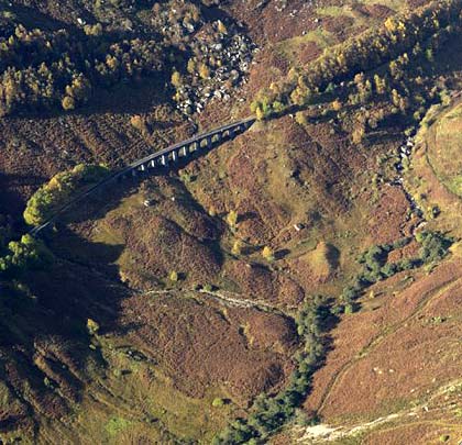
Set high on the side of a dramatic Scottish mountain, Glen Ogle Viaduct comprised part of an ambitious cross-country line connecting Callander with the coastal port of Oban, some 72 miles distant. The western half of the route is still operational. The viaduct’s remote setting ensures it remains an iconic structure, with the classic view of it looking down towards Lochearnhead, the nearest community two miles to the south-east.
The committee of the Callander & Oban Railway held its inaugural meeting in June 1864, although the route had been surveyed two years earlier. Parliamentary authority for construction of the line was granted on 5th July 1865. By the time the last section was opened in June 1880, the aggregate cost of construction amounted to £670,000.
The southernmost section of 17½ miles, as far as the head of Glen Ogle, was awarded to Edinburgh contractor John McKay in October 1866. He immediately set upwards of 700 men on with the task of building it; this figure exceeded 13,000 when work was at its peak. In charge of the engineering were Messrs B & E Blyth.
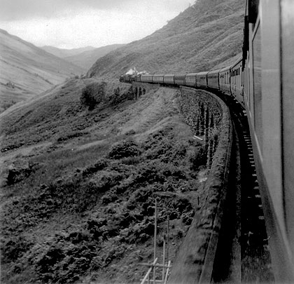
It was 1st June 1870 when trains first rose to the challenge posed by the climb up Glen Ogle, clinging to its west side whilst rising at 1:60 for six miles. Not far from the summit, the line curved eastwards on a radius of about 20 chains to cross a three-arched bridge, followed almost immediately by the 12 segmental arches of Glen Ogle Viaduct. Although subsequently changed, initial designs record a single structure of 20 arches.
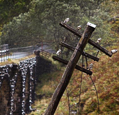
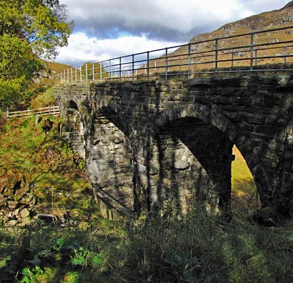
Built in rock-faced stone, the viaduct extends for 150 yards with the northernmost third being straight in plan. It carried a single track. The tapered piers still feature four projections on each side at springing level, used to support the arches’ timber centring. A single refuge is provided above one of the piers. The abutments are skewed due to the land falling away to the east. Telegraph wires were carried on poles alongside the viaduct, one of which remains, albeit no longer vertical.
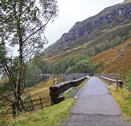
This section of line from Balquhidder to Killin Junction was cited for closure in November 1965, however a landslide to the south of the viaduct brought a slightly premature end to services on 27th September. Since then, much of the parapet on the west side has been lost, but full-length handrails were installed in 2001 as part of the conversion works to host the Rob Roy Way footpath.
The structure was afforded a Grade B listing in October 1971.