Cullen Viaduct
Cullen Viaduct
![Counting from the east, the Burn of Cullen flows beneath the fourth of the viaduct's eight wide arches.](http://www.forgottenrelics.org/wp-content/uploads/2023/03/image1-270.jpg)
![The structure towers over the roofs of Seatown, carrying the trackbed at a height of 78 feet.](http://www.forgottenrelics.org/wp-content/uploads/2023/03/image2-270.jpg)
![Stalactites have formed as a result of mineral-laden water seeping from the stonework.](http://www.forgottenrelics.org/wp-content/uploads/2023/03/image3-270.jpg)
![One house boasts a fabulous view of the viaduct's western end.](http://www.forgottenrelics.org/wp-content/uploads/2023/03/image4-267.jpg)
![The area beneath the arches' brick soffits has been neatly landscaped.](http://www.forgottenrelics.org/wp-content/uploads/2023/03/image5-263.jpg)
![The 204-yard long structure - now part of a Sustrans foot and cycle path - peers out to sea.](http://www.forgottenrelics.org/wp-content/uploads/2023/03/image6-254.jpg)
![A set of steps connects North Deskford Street with the main road, passing beneath a bridge which once carried the railway.](http://www.forgottenrelics.org/wp-content/uploads/2023/03/image7-240.jpg)
![A four-arched structure spans North Castle Street.](http://www.forgottenrelics.org/wp-content/uploads/2023/03/image8-211.jpg)
![Seafield Street passes beneath a bridge which separately accommodates foot traffic.](http://www.forgottenrelics.org/wp-content/uploads/2023/03/image9-176.jpg)
![A green-blue liveried Swindon DMU heads west on the 13th April 1968, affording passengers a wonderful view of the coastline.](http://www.forgottenrelics.org/wp-content/uploads/2023/03/image10-128.jpg)
![The south side of the viaduct, captured before the motor car's arrival.](http://www.forgottenrelics.org/wp-content/uploads/2023/03/image11-107.jpg)
![](http://www.forgottenrelics.org/wp-content/uploads/2023/03/image1-270.jpg)
![](http://www.forgottenrelics.org/wp-content/uploads/2023/03/image2-270.jpg)
![](http://www.forgottenrelics.org/wp-content/uploads/2023/03/image3-270.jpg)
![](http://www.forgottenrelics.org/wp-content/uploads/2023/03/image4-267.jpg)
![](http://www.forgottenrelics.org/wp-content/uploads/2023/03/image5-263.jpg)
![](http://www.forgottenrelics.org/wp-content/uploads/2023/03/image6-254.jpg)
![](http://www.forgottenrelics.org/wp-content/uploads/2023/03/image7-240.jpg)
![](http://www.forgottenrelics.org/wp-content/uploads/2023/03/image8-211.jpg)
![](http://www.forgottenrelics.org/wp-content/uploads/2023/03/image9-176.jpg)
![](http://www.forgottenrelics.org/wp-content/uploads/2023/03/image10-128.jpg)
![](http://www.forgottenrelics.org/wp-content/uploads/2023/03/image11-107.jpg)
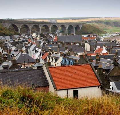
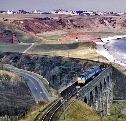
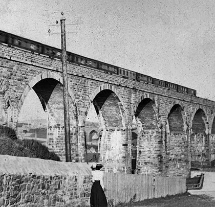
The Great North of Scotland Railway opened its through line along the Moray coast in April 1886, connecting Portsoy with Elgin. The central section included a number of significant structures including the impressive Cullen Viaduct which looks out to sea over the rooftops of Seatown.
The Grade B listed structure is formed of bullfaced rubble with eight rusticated ashlar arch rings and brick soffits. Work on it started in 1884 under the auspices of engineer P M Barnett. It was necessitated by the Seafield Estate’s refusal to allow the railway to encroach onto its land further south near Cullen House.
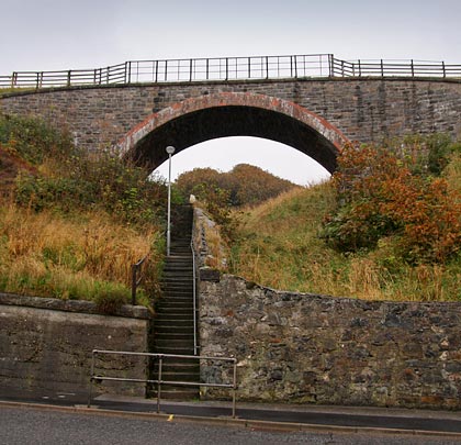
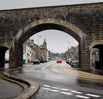
Further east are three more structures – a single span over steps connecting North Deskford Street with the main road, a four-arch viaduct across North Castle Street and another four-arched bridge, with separate accommodate for those on foot, at the bottom of Seafield Street. All these structures were built for a single track.
The line closed on 6th May 1968 but the parts of the line have since been reopened as part of the Moray Firth Trail.