




Conspiracy of circumstance
Conspiracy of circumstance
Eye-catching images were doing the rounds on social media early on the morning of Sunday 14 December 2025. They showed a substantial metal viaduct, with one pier lost and two span ends submerged in a river. The immediate instinct was to assume an AI hoax. In this case though, what was depicted proved only too real.
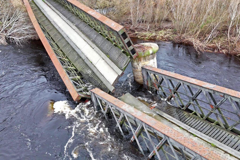
Photo: Trevor Moore
Featured was a legacy railway structure in north-east Scotland that hadn’t carried a train since 1968. Subsequently acquired by Moray Council, it had been repurposed for walking and cycling in July 1981, forming part of a well-used route. One local claimed to have crossed the structure just minutes before it fell. Police soon attended and cordoned it off.
“The collapse appears to be due to scour”, the council asserted the following day after an initial inspection by engineers, with support washed away from around the missing pier. Photographs suggest there had been lateral movement at its base whilst the deck offered resistance at the top. This caused one of its two columns to topple over sideways and the span ends to drop. The second column adopted a lean whilst the other end of the spans remained supported.
Change of plan
Built on an east-west alignment, Spey Viaduct is one of those landscape-defining features that only the Victorians would build. The Great North of Scotland Railway along the Moray Firth coast did not connect major conurbations or promise huge receipts. It was a late addition to the network, presented to Parliament for authorisation in the 1881/82 session. But this was an era of courage and ambition; the heavy engineering demanded through the line’s central section did not deter.
Before joining the sea near Garmouth, the energetic and meandering River Spey would – when in spate – spread itself out over the low banks to follow multiple channels. The original intention of Patrick Barnett, the railway’s engineer, was to bridge the three largest channels with separate structures; however, the Duke of Richmond and Gordon opposed this approach as it would interfere with his salmon fishing rights. The price for his support was a redesign, involving remodelling of the watercourse and provision of a long single span accommodating the river when conditions were normal.
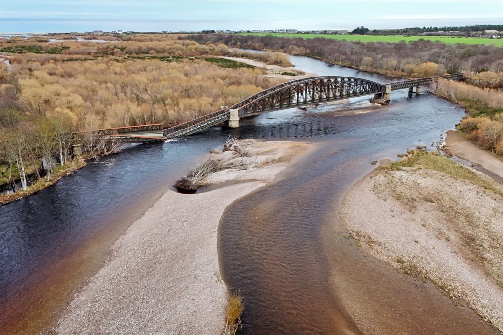
Photo: Trevor Moore
Barnett’s solution was a bowstring span the likes of which Scotland had never seen before: 368 feet in length and more than 40 feet deep. To both sides, three lattice girder spans – each 100 feet long – would allow for the passage of water during times of flood.
The contract was awarded in January 1883, with Blaikie Brothers of Aberdeen successfully tendering. W George Hind was sub-contracted to deliver the masonry works. Excavations got underway in June 1883, served by pumps, steam cranes and a 500-feet long aerial ropeway to carry men across the river.
A losing battle
A paper from the Institution of Civil Engineers and an archive of local newspapers helpfully offer chapter and verse on the construction process. Four test bores were initially sunk through the shingle to find material suitable for the pier and abutment foundations, with red sandstone recorded at a depth of 10-25 feet.
At the western end of the site, excavations for the abutment and piers were completed satisfactorily through manual digging and timbering. However, around 40 feet east of where the collapsed pier was located, the sandstone layer was found to dip away sharply; in other places, it was fragmented or entirely absent. This prompted Mr Hind to admit defeat and walk away. Two other firms declined an offer to replace him before John Fyfe of Aberdeen took on the job.
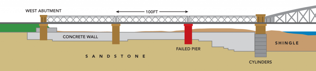
To overcome the foundation problems, Fyfe assembled cast iron cylinders which, for the main span’s piers, had a diameter of 15 feet and comprised six segments, 5 feet high and 1¼ inches thick. For the eastern spans, the cylinders were 9 feet 3 inches in diameter. All were sunk into the river bed under loading of up to 130 tons, before teams of navvies used picks and shovels to remove the contents. This process was repeated until a firm footing was found, 39-46 feet below ground level. To provide internal strength, the completed columns were filled with concrete. The piers were then built up from the cylinders in freestone masonry, with rustic ashlar added as a facia. Granite was used for the bearing blocks.
The stonework was completed in February 1885, allowing work to get underway on the superstructure, a process which took just ten months. Meanwhile, Fyfe’s labourers built 4-feet thick concrete walls under the side spans – at an average depth of 16 feet below ground – to reduce the risk of scour and encourage flows towards the main span; protection walls were also built around the ends of the approach embankments. This work was the precursor to a major operation by which the Spey would be diverted.
Hundreds of navvies toiled for six months to establish a new channel, rioting on one occasion when Fyfe refused to pay them an extra 4d per hour. Around 150 feet wide and 4 feet deep, the excavation extended upstream for almost a mile. At 2pm on 26 January 1886, half-a-dozen men in sea boots used sledgehammers to demolish a temporary barrier, allowing the river to flow under the bowstring span.
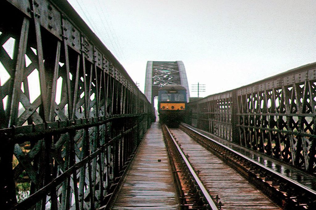
Photo: Mike Mitchell/GNSRA
But ultimately the Spey was having none of it. Despite a series of expensive remedial interventions, the river chose its own course, mostly under the eastern spans. The Duke took the railway to court – determined to protect his fishing – but the case was lost.
Listen and learn
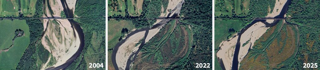
Embedded within the communities alongside the Spey is deep accumulated insight into its behaviour. Local sources suggest that, in 1995, the river was diverted eastwards whilst repairs were undertaken to bank defences upstream of the viaduct. But it was never put back. Since then, migration of the main channel, reworking of its flood plain and erosion has accelerated, reaching the front door of a dwelling, Ross House, which was subsequently demolished.
Measurements from aerial imagery suggest the river has moved west by 600 metres in 20 years. Flooding in Garmouth is reported to have increased from, typically, one or two days per year to 11 days in the five-month period starting October 2020.
In 2021, Innes Community Council commissioned cbec eco-engineering to consider what might be done. The company proposed the construction of a sustainable ‘log-jam’ whereby the river would be guided back eastwards into the dominant channel it occupied in 2014. The indicative design proposed a large wooden structure comprising timber posts, fallen trees and sediment excavated as part of works to reprofile the river bed. Its estimated cost was £82K.
Somewhat prophetically, the report stated that “The highly dynamic nature of the Lower Spey in the vicinity of the Spey Viaduct means that if left unchecked, continuing erosion of the left bank at Ross House poses a potential risk of destabilising adjacent infrastructure, properties, local amenities, and land use.”
The document was submitted to Moray Council by Notice of Motion in September 2021. However, the authority made clear that it could not progress the scheme as it had played no part in developing it. Instead, seven alternative options were put forward – with two being further developed subsequently – but council policy prevented any from being implemented as Garmouth is not included in its Flood Risk Management Plans due to the perceived low value-for-money of works there – an assessment that took no account of the social and economic impacts of losing the viaduct. It was therefore left to the community to fund any project. None has yet been delivered.
Then, in 2024, the Spey’s main channel moved again, flowing under the viaduct’s western spans and imposing forces on the now-collapsed pier that it was not intended to withstand. The river then turned at right-angles before heading back towards the sea under the first of the eastern spans. It seems likely that this change in the river’s course will prove to be a key factor in the structure’s demise.
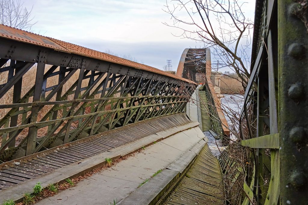
Photo: Moray Council
Speaking to the Scottish Parliament the day after the collapse, Douglas Ross MSP levelled criticism at the Scottish Environment Protection Agency (SEPA) which he claimed had “repeatedly opposed local plans to manage and dredge the river”. He asked the First Minister to instruct SEPA “to stop meddling in such issues, stop prioritising flora and fauna over houses and infrastructure, and allow the management of the rivers that local people know best.”
We asked SEPA for its response to this criticism, but it failed to address any of our specific questions.
Cause for concern?
Emails seen by the regional Press & Journal newspaper indicate that Moray Council employees expressed concerns about Spey Viaduct in 2022 and 2023. In a message to Transport Scotland, one officer asserted that “Its condition is deteriorating and as the river moves there is evidence of scour which could undermine the bridge abutments.” Another suggested that “In time, without repair/improvement the crossing may be lost.”
The council points out that the emails were not written by bridge engineers and “should not be interpreted as providing an engineering assessment or technical opinion”. A 2022 bid for money to carry out a full structural survey of the viaduct remains on the funding body’s reserve list.
The easily accessible parts of Spey Viaduct had been inspected in May 2025, according to the council. This identified some section loss to the ironwork and the need for repainting. Cracking was apparent in one pier; others were affected by mortar loss. Scour of the river bed was recorded at the eastern span, but no evidence of scour had been found when a specialist contractor carried out a more detailed assessment in 2023. Indeed, “scour was not considered to present a risk to the structure”, says the council, as it is “founded on rock”.
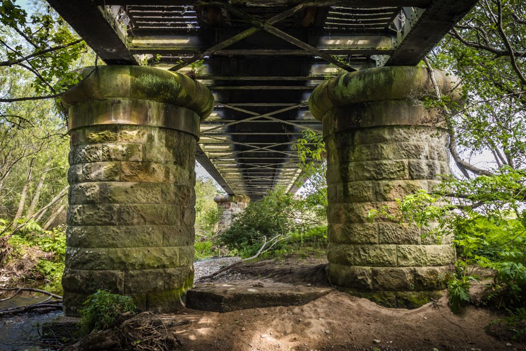
Photo: Forgotten Relics
Local sources report that movement of longitudinal timbers on the structure’s deck was observed as recently as October 2025.
Whatever has gone on in the background, a number of legitimate questions remain unanswered. Have the authorities understood and engaged meaningfully with community unease about the Spey’s westerly migration and increased frequency of flood events? The council believes it has done all it reasonably can; many locals disagree. Was there a conflict between perceived environmental priorities and the imperative of maintaining structural support for the viaduct? That’s a view strongly held by some. Did the council recognise the heightened risk that came with the pier finding itself in the Spey’s main channel, rather than its flood plain? Perhaps not explicitly.
Troubling times
It’s not currently clear what the future holds for Spey Viaduct, except for the immediate priority of making it safe. No option will be cheap given the logistical, environmental and access challenges presented by the Spey. Preliminary discussions with potential funding bodies are at an early stage.
After the railway’s closure, the structure’s dismantling was on the cards; since then, it has become a valued transport asset again, protected by a Category B listing. In the immediate aftermath of the collapse, one resident described locals as “heartbroken”. This might feel overblown to some, but it’s indicative of how these feats can become part of the social fabric. Spey Viaduct was ever-present and some folk interacted with it daily, walking the dog or crossing to reach bus services into Elgin.
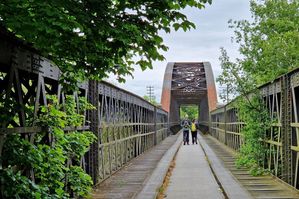
Photo: Forgotten Relics
The structure’s fall into the Spey has created much turbulence hereabouts and a sense of isolation. There are doubts about the sustainability of businesses whose footfall was largely dependent on visitors using the path. The Scottish Dolphin Centre at Spey Bay – formerly a half-hour walk from Garmouth – is now an eight-mile car ride away. It’s not known whether the village coffee house can survive without passing trade. Some within the community feel failed by the authorities – the lack of practical intervention getting lost within a deluge of words. Real damage has been done and not just to a piece of historic infrastructure.
